 Search: public
Filter: Subject of business
Search: public
Filter: Subject of business

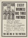
| Date: | |
|---|---|
| Description: | A poster created by Hill and Knowlton, Inc., Public Relations Counsel advertising good public relations. The caption reads: "Sound Public Relations Strengt... |

| Date: | |
|---|---|
| Description: | Vendors sit beside their wares at a public market along a narrow street in La Paz, Bolivia. |

| Date: | 2004 |
|---|---|
| Description: | This map shows ATMs, houses of worship, hotels, parking ramps, public parking, union cab stands, bus stops, business district, parks and public areas, gove... |

| Date: | 1990 |
|---|---|
| Description: | This map shows various types of trails, boat landings, canoe areas, public beaches, picnic areas, campgrounds, golf courses, public tennis courts, and othe... |

| Date: | 1863 |
|---|---|
| Description: | Includes index to public buildings, churches, schools. Inset: Glidden & Lockwood’s addition. Gives names of some property owners. |

| Date: | 1931 |
|---|---|
| Description: | This map of Ashland shows roads, railroads, and local businesses. The map reads: "Showing streets and roads open to the public Oct. 1, 1931." Included on t... |

| Date: | 1910 |
|---|---|
| Description: | This map is a survey of Kenosha Harbor and shows local streets, public buildings, local businesses, and part of Lake Michigan. Included is text on sailing ... |

| Date: | 1987 |
|---|---|
| Description: | This pictorial map shows roads, bridges, local businesses with phone numbers, and public buildings. Relief is shown pictorially. Also included is a calen... |
| Date: | 1873 |
|---|---|
| Description: | This hand-colored map includes business directories, a statistical table, as well as illustrations of public, residential, and commercial properties. Commu... |

| Date: | 1962 |
|---|---|
| Description: | This blue print map shows 5 zoning districts, as well as lot and block numbers and dimensions, public land, streets, and Mill Pond. The zones are: "Single ... |

| Date: | 10 03 1961 |
|---|---|
| Description: | The Madison Chapter of Certified Public Accountants, donate about three nights of work a week to auditing the United Givers fund. Among them are Donald Nel... |
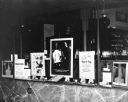
| Date: | 10 13 1940 |
|---|---|
| Description: | Educational window display promoting awareness about tuberculosis at the Frankfurter Pharmacy. |

| Date: | 1890 |
|---|---|
| Description: | Bird's-eye map of Beloit with insets of Williams Engine Works, Eclipse Wind Engine Co., and John Foster & Co. Turtle Creek is in the lower section, and the... |

| Date: | 05 1958 |
|---|---|
| Description: | Photocopy of a map created by the City of Milwaukee Master Plan Program City Planning Division in May of 1958 representing 1870 "THE CENTRAL AREA OF THE CI... |

| Date: | 04 25 1961 |
|---|---|
| Description: | Chief No-Ha-Nutch'Ka,left, who is actually Jack Grey, head of public relations for Wisconsin Dells, gives Chamber of Commerce members tips on how to gain m... |
| Date: | 1918 |
|---|---|
| Description: | Poster with cartoon depicting three men armed with bayoneted rifles, standing in front of a pillar, with factory buildings in the background. The men are w... |

| Date: | 1890 |
|---|---|
| Description: | Studio portrait of Magnus Swenson. He was a Norwegian immigrant who made his name in business and as an inventor. He served on the Wisconsin Capitol Buildi... |

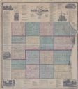
| Date: | 1904 |
|---|---|
| Description: | Map shows townships and sections, landownership and acreages, roads, railroads, post offices, and farms. On the top, bottom, and sides of map are advertise... |
| Date: | 1935 |
|---|---|
| Description: | Skilled Trade Division, at 511-A West Wells Street, Lot 1119. Men's Department-Skilled Trade and Clerical Division; Division for the Physically Disabled. ... |

| Date: | 1966 |
|---|---|
| Description: | This 1966 map shows topography, roads, highways, golf courses, government buildings, and businesses around Delavan Lake in Walworth County, Wisconsin. Incl... |
If you didn't find the material you searched for, our Library Reference Staff can help.
Call our reference desk at 608-264-6535 or email us at: