 Search: public
Filter: Subject of electric power
Search: public
Filter: Subject of electric power

| Date: | 1910 |
|---|---|
| Description: | A corner view of the Courthouse and public square. Utility lines are visible. Baers Stationers. |
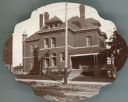
| Date: | 1905 |
|---|---|
| Description: | The Dane County sheriff's residence, with the county jail behind. A corner of the Dane County Court House is seen on the far left. |
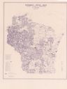
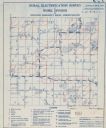
| Date: | 06 1975 |
|---|---|
| Description: | This map shows electrical utilities and cooperatives throughout the state, as well as cities and county boundaries. The bottom left corner of the map inclu... |
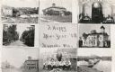
| Date: | 1909 |
|---|---|
| Description: | Composite of views of Muscoda including: Electric Light plant, Smalley House, St. John Catholic Church, Lover's Lane, Muscoda Public School, Wisconsin Aven... |
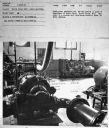
| Date: | 1950 |
|---|---|
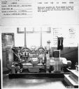
| Description: | Subject: "Municipalities." Where Taken: "MW." Information with photograph reads: "Ready-Power Generator Set, UD-18A powered in plant of Department of Publi... |

| Date: | |
|---|---|
| Description: | Interior of the Black River Falls powerhouse. |

| Date: | |
|---|---|
| Description: | Interior of the Black River Falls powerhouse. |
| Date: | 1950 |
|---|---|
| Description: | Subject: "Municipalities." Where Taken: "MW." Information with photograph reads: "Ready-Power Generator Set, UD-18A powered in plant of Department of Publi... |
| Date: | 1950 |
|---|---|
| Description: | Subject: "Municipalities." Where Taken: "MW." Information with photograph reads: "Ready-Power Generator Set, UD-18A powered in plant of Department of Publi... |
| Date: | 1950 |
|---|---|
| Description: | Subject: "Municipalities." Where Taken: "MW." Information with photograph reads: "Ready-Power Generator Set, UD-18A powered in plant of Department of Publi... |
| Date: | |
|---|---|
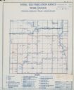
| Description: | Rural electrification survey map of Marquette county in Westfield township. |
| Date: | |
|---|---|
| Description: | Rural electrification survey map of Waushara county in Springwater township. |
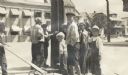
| Date: | |
|---|---|
| Description: | A group of boys gathered around a telephone pole on a street corner, captioned: "Inquisitiveness: Getting an Electric Shock." A boy on the left has some ki... |
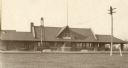
| Date: | 1900 |
|---|---|
| Description: | Front view of the Wausau Railroad Station with power lines in the foreground. |
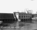
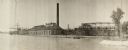
| Date: | 1929 |
|---|---|
| Description: | Elevated view across reservoir of dam and power plant. |
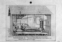
| Date: | 1882 |
|---|---|
| Description: | Cutaway view of the building that housed the first electrical station created to distribute incandescent light electricity. |
| Date: | 1940 |
|---|---|
| Description: | Aerial view of the Wisconsin Power and Light Company generating plant and dam. |
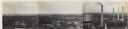
| Date: | 1930 |
|---|---|
| Description: | Panoramic elevated view to the northeast from the Capitol Square. |
| Date: | 1922 |
|---|---|
| Description: | Appleton Wisconsin Electric Light and Power Plant, 1922. Switchboard equipment of the plant, which began operating in September of 1822, is at the State Hi... |

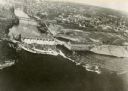
| Date: | 1930 |
|---|---|
| Description: | Aerial view of Wisconsin Dells including the Wisconsin River and the dam and generating power plant. |
If you didn't find the material you searched for, our Library Reference Staff can help.
Call our reference desk at 608-264-6535 or email us at: