 Search: public
Filter: Subject of express highways
Search: public
Filter: Subject of express highways

| Date: | 1975 |
|---|---|
| Description: | This map shows nature trails, public attractions, public hunting and fishing grounds, dams, waysides, lakes, highways, and roads. The upper right corner in... |

| Date: | 1939 |
|---|---|
| Description: | This nine-part map from the U.S. Bureau of Public Roads identifies federal and state highways in Wisconsin by pavement type. County, forest, park, and publ... |

| Date: | 1935 |
|---|---|
| Description: | This three-part map from the U.S. Bureau of Public Roads identifies highways in Wisconsin that have been improved, indicating those which are federal highw... |

| Date: | 1956 |
|---|---|
| Description: | Shows roads, railroads, highways, boundaries, and other public facilities and areas. Includes location map and legend. "Corrected for Feb. 1956." "Correcte... |
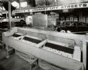
| Date: | 08 1948 |
|---|---|
| Description: | Exhibit in the Transportation Building at the Wisconsin Centennial Exposition, which included this model from the U.S. Public Roads Association. The model ... |

| Date: | 1944 |
|---|---|
| Description: | This nine-part map from the U.S. Bureau of Public Roads identifies federal and state highways in Wisconsin by pavement type. County, forest, park, and publ... |

| Date: | 1986 |
|---|---|
| Description: | This late 1980s map of Price County, Wisconsin, shows facilities and lands open for public recreation, hunter walking trails and ski trails, campgrounds, b... |

| Date: | 1829 |
|---|---|
| Description: | This map of Munnomonee is ink and pencil on tracing cloth. The map shows a plat of the town, local streets, highways, land donations for public use, and pa... |

| Date: | 1960 |
|---|---|
| Description: | This map shows public boat ramps, parks, highways, beaches, bluffs, Green Bay, Garrett Bay, Europe Bay and Lake, Rowley's Bay and Ellison Bay. The map incl... |

| Date: | 1966 |
|---|---|
| Description: | This map includes a red overprint on base map and shows the supervisors and district numbers of St. Croix County. Includes diagrams of civil towns, townsh... |
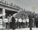
| Date: | 10 17 1961 |
|---|---|
| Description: | Governor Gaylord Nelson with local civic leaders at the dedication of a portion of Interstate Highway I-90. Congressman Robert Kastenmeier is standing at t... |
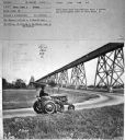
| Date: | 1950 |
|---|---|
| Description: | Subject: "Inter. Super A — Mowing." Where Taken: "SE." Information with photograph reads: "Photo shows first International Super A tractor and AI-23 highwa... |

| Date: | 1976 |
|---|---|
| Description: | This 1976 map of Washington County, Wisconsin, shows towns, cities and villages, highways and roads, existing and proposed county trails, and various publi... |
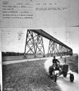
| Date: | 1950 |
|---|---|
| Description: | Subject: "Inter. Super A — Mowing." Where Taken: "SE." Information with photograph reads: "Photo shows first International Super A tractor and AI-23 highwa... |
| Date: | 1953 |
|---|---|
| Description: | This map of Beloit shows existing platted streets or highways and proposed street right of way. The map reads: "I hereby certify that this is the official ... |
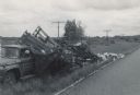
| Date: | 06 07 1966 |
|---|---|
| Description: | View from road of a truck pulled off to the side of the road. The back of the truck is collapsed, containing beehives spilling onto the ground. "E.R. Raley... |

| Date: | 1922 |
|---|---|
| Description: | A road map of Milwaukee County, Wisconsin that shows the township and range system, towns, communities, completed roads, a proposed system of roads, steam ... |

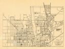
| Date: | 1976 |
|---|---|
| Description: | A street map of Milwaukee County, Wisconsin that identifies the location of schools, hospitals, parks, beaches, streets, freeways, both planned or under co... |

| Date: | 1919 |
|---|---|
| Description: | "Map no. 2, Keith and Hiles Lumber Co., Crandon, Wisconsin, Block Map, Block One... Made December 20, 1919. Maker of original map, B. McGinley. Maker of ta... |

| Date: | 1930 |
|---|---|
| Description: | This map shows the state trunk highway system and county trunk highways. This map show surface type on state and county trunk highways and the locations of... |
If you didn't find the material you searched for, our Library Reference Staff can help.
Call our reference desk at 608-264-6535 or email us at: