 Search: public
Filter: Subject of fishing
Search: public
Filter: Subject of fishing

| Date: | 1975 |
|---|---|
| Description: | This map shows nature trails, public attractions, public hunting and fishing grounds, dams, waysides, lakes, highways, and roads. The upper right corner in... |

| Date: | 1958 |
|---|---|
| Description: | This map shows state public hunting and/or fishing grounds, national forests, state forests, county forests.The lower margin includes an index to these loc... |

| Date: | 1960 |
|---|---|
| Description: | This map shows improved town roads, federal highways, county highways, public boat access, public hunting areas, railroads, and lakes in the area around th... |

| Date: | 1970 |
|---|---|
| Description: | This map shows roads, parks, swimming beaches, golf courses, yacht harbors, light houses, airports, public hunting grounds, waysides, schools, and fishing ... |
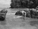
| Date: | 12 1942 |
|---|---|
| Description: | Olive Brooks, Division Engineer Public Relations, collecting dead fish after throwing dynamite into the water. She is holding a fish and has her pants roll... |

| Date: | 1976 |
|---|---|
| Description: | Panel title. Shows railroads, roads, highways, boundaries, dams, public hunting and fishing grounds, cemeteries, forest ranger stations, plant life, and s... |

| Date: | 1991 |
|---|---|
| Description: | This map shows public access, fish crib locations, resorts, and other local businesses as well as advertisements for local attractions and a resort index. ... |

| Date: | 1986 |
|---|---|
| Description: | This late 1980s map of Price County, Wisconsin, shows facilities and lands open for public recreation, hunter walking trails and ski trails, campgrounds, b... |

| Date: | 1968 |
|---|---|
| Description: | Shows potential fishing areas by species and season, as well as sand and rock bars, weed beds, public facilities, points of interest, and selected business... |

| Date: | 1980 |
|---|---|
| Description: | This map shows schools, hotels, stations, roads, railroads, reefs, and public buildings. The upper right corner includes "A Summer and Winter Guide for Spo... |
| Date: | 07 1946 |
|---|---|
| Description: | Dwight D. Eisenhower, fishing with his brothers on Wisconsin Lake, proudly exhibit Muskies and one Northern Pike. |

| Date: | 1994 |
|---|---|
| Description: | This map shows historical sites, picnic grounds, public boat landings, canoe and motor boat trips, and resort locations. The left margin of the map include... |
| Date: | |
|---|---|
| Description: | During his career as an entertainer and magician, Ben Bergor of Madison also booked the acts and served as master of ceremonies for many sports shows aroun... |

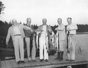
| Date: | 1956 |
|---|---|
| Description: | Dwight D. Eisenhower and his brothers on a fishing trip proudly exhibiting muskies and northern pike on a Wisconsin lake. From left are Dwight, Edgar, Milt... |

| Wisconsin Historical Museum Object – Feature Story |
|---|
| Concrete walleye decoy purchased at PARR Rally in Minocqua, Wisconsin, April 15, 1989. (Museum object #1990.178.1) |
If you didn't find the material you searched for, our Library Reference Staff can help.
Call our reference desk at 608-264-6535 or email us at: