 Search: public
Filter: Subject of land use, urban
Search: public
Filter: Subject of land use, urban

| Date: | 1905 |
|---|---|
| Description: | This blueprint map shows rivers, land parcels, and streets. It also highlights selected public and industrial buildings. |
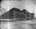
| Date: | 05 16 1902 |
|---|---|
| Description: | Milwaukee Public Library building (Central Library) at W. Wisconsin Avenue and N. 9th Street. |
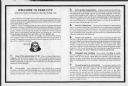
| Date: | |
|---|---|
| Description: | Guidelines prepared and distributed as a public service by the Council For Public Safety in New York, NY. A pamphlet survival guide for visitors to the cit... |

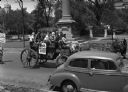
| Date: | 1915 |
|---|---|
| Description: | International Model F or 31 truck used for public transportation parked in urban area. Next to the open door on the side of the truck it reads: "Pay As You... |

| Date: | |
|---|---|
| Description: | Men and women are strolling and conversing in a public garden. Hand-tinted lantern slide. |
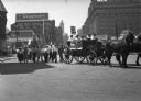
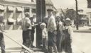
| Date: | 07 13 1946 |
|---|---|
| Description: | A United Public Workers parade/demonstration from an adjacent sidewalk. The line of participants including a horse-drawn wagon stretches into the distance.... |
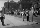
| Date: | 07 13 1946 |
|---|---|
| Description: | Part of a United Public Workers parade/demonstration on a downtown city street. A horse-drawn wagon carries some participants. Parade signs read "No Swivel... |
| Date: | 07 13 1946 |
|---|---|
| Description: | View from sidewalk of horse-drawn wagon on a tree-lined city street in a United Public Workers parade/demonstration. The wagon has a number of boys in it w... |

| Date: | 01 19 1945 |
|---|---|
| Description: | Edgewood fence along Wingra Drive entrance which had been opened to the public after closing by the Dominican Sisters of Edgewood Academy. |
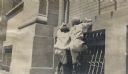
| Date: | |
|---|---|
| Description: | Two boys attempting to climb a wall on the facade of a building near a window. |
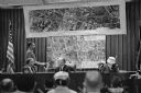
| Date: | 11 09 1960 |
|---|---|
| Description: | A display to illustrate proposed improvements to the Madison Beltline highway at a hearing in the City-County Building by the State Highway Commission. |

| Date: | 1850 |
|---|---|
| Description: | This map of the Town of Lake is ink and pencil on paper and shows lots and acreages, reserved land, and public squares. The bottom of the map includes a ke... |
| Date: | |
|---|---|
| Description: | A group of boys gathered around a telephone pole on a street corner, captioned: "Inquisitiveness: Getting an Electric Shock." A boy on the left has some ki... |
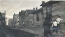
| Date: | |
|---|---|
| Description: | Children having a stone fight in an unpaved alley or street in an underprivileged neighborhood. Some of the boys are holding trash can lids as protection, ... |

| Date: | 1829 |
|---|---|
| Description: | This map of Munnomonee is ink and pencil on tracing cloth. The map shows a plat of the town, local streets, highways, land donations for public use, and pa... |
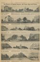
| Date: | 1956 |
|---|---|
| Description: | Capitol Square images from a 1956 Wisconsin State Journal article. |

| Date: | |
|---|---|
| Description: | A group of boys take a boxing stance near two men standing on a street corner, in front of a building that has "Milwaukee Beer" painted on it. |

| Date: | 1960 |
|---|---|
| Description: | Senator John F. Kennedy campaigning at a labor rally. |

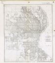
| Date: | 1902 |
|---|---|
| Description: | This map is a chart of Milwaukee Harbor that displays local streets, bridges, roads, railroads, public buildings, businesses, factories, dry docks, parks, ... |
| Date: | 12 11 1933 |
|---|---|
| Description: | This map shows residence, business, commercial, and industrial districts as well as streets, points of interest, and Lake Michigan. |
If you didn't find the material you searched for, our Library Reference Staff can help.
Call our reference desk at 608-264-6535 or email us at: