 Search: public
Filter: Subject of lighthouses
Search: public
Filter: Subject of lighthouses

| Date: | 1950 |
|---|---|
| Description: | This map of Sturgeon Bay is part of the survey of the northern and northwestern lakes. The map shows lights, railroads, roads, and some public buildings. R... |

| Date: | 1970 |
|---|---|
| Description: | This map shows roads, parks, swimming beaches, golf courses, yacht harbors, light houses, airports, public hunting grounds, waysides, schools, and fishing ... |
| Date: | |
|---|---|
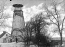
| Description: | View toward a man standing in front of the Barcelona Lighthouse, believed to be the oldest existing structure of its kind on the Great Lakes. The lighthous... |

| Date: | |
|---|---|
| Description: | A view of the Charlotte-Genesee Lighthouse, constructed in 1822 on a hill just west of the Genesee River, covered in vines. This light was built in 1822 (n... |
| Date: | 1929 |
|---|---|
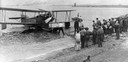
| Description: | A Loening Amphibian, one of three such airplanes in which the Kohler Aviation Company provided passenger service from Milwaukee across Lake Michigan. |
| Date: | |
|---|---|
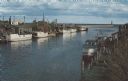
| Description: | Color photographic postcard of the fisherman's dock taken from the harbor walkway. White boats are moored on either side of the Ahnapee River as it flows i... |

| Speakers Bureau |
|---|
| Pamela Cameron is a WHS Press author and a member of the Wisconsin Historical Society Speakers Bureau. |
| Date: | |
|---|---|
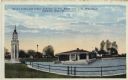
| Description: | Hand-colored postcard view of the lighthouse and boathouse at Bray's Point. Caption reads: "Bray's Point and Light, Junction of Fox River with Lake Winneba... |
If you didn't find the material you searched for, our Library Reference Staff can help.
Call our reference desk at 608-264-6535 or email us at: