 Search: public
Filter: Subject of maps
Search: public
Filter: Subject of maps
| Date: | 06 1930 |
|---|---|
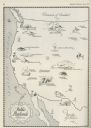
| Description: | A map of the western states showing "public playlands," mostly national parks. |
| Date: | 1974 |
|---|---|
| Description: | Flyer advertising a May Day rally in support of public workers to be held at Library Mall on the University of Wisconsin-Madison campus. Local public worke... |

| Date: | 1975 |
|---|---|
| Description: | This map shows nature trails, public attractions, public hunting and fishing grounds, dams, waysides, lakes, highways, and roads. The upper right corner in... |

| Date: | 1958 |
|---|---|
| Description: | This map shows state public hunting and/or fishing grounds, national forests, state forests, county forests.The lower margin includes an index to these loc... |

| Date: | 1890 |
|---|---|
| Description: | This map oriented with north towards the upper right shows sewers, cases of diphtheria and scarlet fever, schools, and public buildings. Lake Wingra is lab... |
| Date: | 11 1973 |
|---|---|
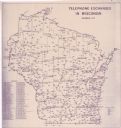
| Description: | This map shows the cities, county boundaries and telephone exchange locations. The map includes a numbered list of telephone companies. |
| Date: | 1974 |
|---|---|
| Description: | This blue line map show gas services and county boundaries. Includes a legend of company names in lower left hand corner. |
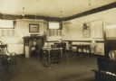
| Date: | |
|---|---|
| Description: | Interior view of the Elroy Public Library. The library opened in 1908 and was funded by Andrew Carnegie with $10,000. On the lower right the cardboard back... |
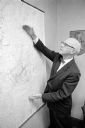
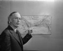
| Date: | 08 13 1965 |
|---|---|
| Description: | H.O. Lord, Madison Metropolitan Sewerage District chief engineer, outlining the existing sewerage district on a map. Lord is trying to educate the public c... |
| Date: | 06 1975 |
|---|---|
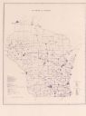
| Description: | This map shows electrical utilities and cooperatives throughout the state, as well as cities and county boundaries. The bottom left corner of the map inclu... |
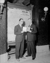
| Date: | 05 27 1941 |
|---|---|
| Description: | Secretary of State Fred R. Zimmerman and Robert "Bob" Brayton, Public Relations Director or the American Automobile Association. They are standing in front... |
| Date: | 09 20 1947 |
|---|---|
| Description: | James L. Clark, Madison city health inspector, shown pointing to a map of Madison marked with X's signifying places with rat infestation. |
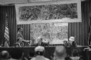
| Date: | 11 09 1960 |
|---|---|
| Description: | A display to illustrate proposed improvements to the Madison Beltline highway at a hearing in the City-County Building by the State Highway Commission. |
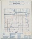
| Date: | |
|---|---|
| Description: | Rural electrification survey map of Marquette county in Westfield township. |
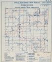
| Date: | |
|---|---|
| Description: | Rural electrification survey map of Waushara county in Springwater township. |
| Date: | |
|---|---|
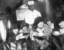
| Description: | A tea party on an airplane, a publicity stunt conceived by Harry Bruno to promote his Cleveland-area airline, Aeromarine Airlines. By taking local reporter... |

| Date: | 01 25 1961 |
|---|---|
| Description: | A committee begins to plan Madison Women's 1961 City Golf Tournament at the Community Center. Shown (from left) are: Mrs. Jane Brandt, Public Links Courses... |
| Date: | |
|---|---|
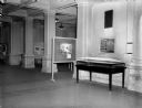
| Description: | Art exhibit on the first floor of the State Historical Society of Wisconsin Building. |

| Date: | 1871 |
|---|---|
| Description: | This map shows the entire state, county boundaries, railroads, cities and towns, Lake Superior, and the extent of surveyed townships with Public Land Surve... |

| Date: | 01 09 1948 |
|---|---|
| Description: | Portrait of Julius Kelly, newly elected County Treasurer by the Dane County Board. |
If you didn't find the material you searched for, our Library Reference Staff can help.
Call our reference desk at 608-264-6535 or email us at: