 Search: public
Filter: Subject of parks
Search: public
Filter: Subject of parks

| Date: | 1959 |
|---|---|
| Description: | This map shows public access sites, public beaches and parks, other public shorelines, boat liveries, public hunting and fishing grounds, railroads, roads,... |
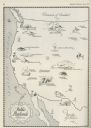
| Date: | 06 1930 |
|---|---|
| Description: | A map of the western states showing "public playlands," mostly national parks. |

| Date: | 2000 |
|---|---|
| Description: | This map shows Wisconsin Public Service Corporation property, special regulation areas, public boat landings, roads, parks, and other recreation areas. Ins... |

| Date: | 1961 |
|---|---|
| Description: | This map shows the lake, clubs, resorts, motels, school house, public approaches, and public parks. The back of map includes advertisements and text. |

| Date: | 1907 |
|---|---|
| Description: | View of a fountain on a pedestal in a park. Caption reads: "W.C.T.U. Public Fountain, Lake Mills, Wis." |
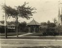
| Date: | |
|---|---|
| Description: | Gazebo in Library Park behind the Watertown Public Library. The gazebo has a clay tile roof, and there are also benches, trellises, and a fountain. A churc... |
| Date: | |
|---|---|
| Description: | Gazebo in Library Park behind the Watertown Public Library. The gazebo has a clay tile roof, and there are benches, and trellises around it. Two dogs stand... |
| Date: | 1927 |
|---|---|
| Description: | Old Soldiers' Reunion on the public square. |

| Date: | 2004 |
|---|---|
| Description: | This map shows ATMs, houses of worship, hotels, parking ramps, public parking, union cab stands, bus stops, business district, parks and public areas, gove... |

| Date: | 1939 |
|---|---|
| Description: | This nine-part map from the U.S. Bureau of Public Roads identifies federal and state highways in Wisconsin by pavement type. County, forest, park, and publ... |

| Date: | 1900 |
|---|---|
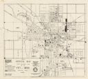
| Description: | This map is indexed and shows numbering system, public buildings and parks, wards, and voting booths. |

| Date: | 1900 |
|---|---|
| Description: | This map includes an index of streets and schools, and shows parks and public lands, as well as industrial sites. |

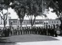
| Date: | 08 13 1960 |
|---|---|
| Description: | Score sheets for the 1960 City Public Golf Links Tournament at the West Side Park (Odana) are examined by, left to right, Bob Scholl, tournament co-directo... |
| Date: | 1961 |
|---|---|
| Description: | This map shows platted and proposed streets, streets to be widened, proposed pedestrian paths, lot and block numbers, city wards, public buildings, and par... |
| Date: | |
|---|---|
| Description: | The replica of the Centennial Fountain in the Capitol Park. |
| Date: | 1924 |
|---|---|
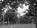
| Description: | A swing set at a public park. There is a windmill in the background. |

| Date: | |
|---|---|
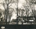
| Description: | View across path and lawn towards groups of people among trees in a public park. Hand-tinted lantern slide. |

| Date: | 1887 |
|---|---|
| Description: | This map shows block numbers, roads, railroads, wards, and selected buildings. The map includes a "Milwaukee city street guide" and index to public buildin... |

| Date: | 1890 |
|---|---|
| Description: | This map shows city wards, block numbers, parks, cemeteries, roads, railroads, and selected buildings. The map includes indexes to streets, public building... |
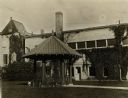
| Date: | |
|---|---|
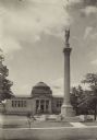
| Description: | Exterior view of park in front of the Gilbert M. Simmons Public Library, with the Soldiers and Sailors monument. The library opened in 1900 and was funded ... |
If you didn't find the material you searched for, our Library Reference Staff can help.
Call our reference desk at 608-264-6535 or email us at: