 Search: public
Filter: Subject of ponds
Search: public
Filter: Subject of ponds
| Date: | |
|---|---|
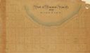
| Description: | This plat map is pen, pencil, and watercolor on paper and shows numbered blocks and lots, local streets, section lines, the public square, Mill pond, and l... |
| Date: | |
|---|---|
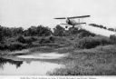
| Description: | View of a crop duster spraying a pesticide to control Malaria mosquitoes over a pond. The caption under the image reads: "Aerial 'Gas' Attack Annihilates a... |

| Date: | 1962 |
|---|---|
| Description: | This blue print map shows 5 zoning districts, as well as lot and block numbers and dimensions, public land, streets, and Mill Pond. The zones are: "Single ... |
| Date: | 1929 |
|---|---|
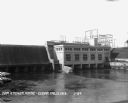
| Description: | Elevated view across reservoir of dam and power plant. |
| Date: | 1924 |
|---|---|
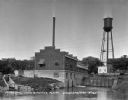
| Description: | The Municipal Light and Power Plant and water tower seen from across a pond. |

| Date: | 1776 |
|---|---|
| Description: | Fairly detailed map of New York City and parts of Long Island. It shows streets, roads, wharves, ferries, ship yards, Fort George and the battery, public b... |
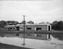
| Date: | 10 06 1949 |
|---|---|
| Description: | The Town of Madison's new building houses the town offices, garage, and fire department. There is a pond in the foreground. |

| Date: | 1789 |
|---|---|
| Description: | Map of New York City showing ward boundaries, ferries, streets, roads, swamps, ponds, and rivers. The properties of Lispinard, Byards, Jones, Rutgers, and ... |

| Date: | 1893 |
|---|---|
| Description: | A view of the World's Columbian Exposition mounted on a cardboard album page, looking east from the Transportation Building. On the right are the Mines Bui... |
If you didn't find the material you searched for, our Library Reference Staff can help.
Call our reference desk at 608-264-6535 or email us at: