 Search: public
Filter: Subject of railroad stations
Search: public
Filter: Subject of railroad stations

| Date: | 1907 |
|---|---|
| Description: | Shows public buildings, hotels, fraternity houses, and private houses. Index of fraternities and sororities, residences, public buildings, hotels, places o... |

| Date: | 1878 |
|---|---|
| Description: | This bird’s-eye-view map of Barton is indexed for parochial and public schools, churches, a convent, the railroad depot, and the post office. |

| Date: | 12 1912 |
|---|---|
| Description: | Sanborn Map of Sun Prairie. The map highlights the public and parochial schools, the exhange, and church buildings, etc. |
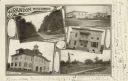
| Date: | 1905 |
|---|---|
| Description: | Photographic postcard of a collage of 5 views of Brandon including; Washington St., Public Square, Times Office, High School, and Depot & Park. |
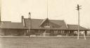
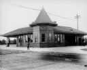
| Date: | 1900 |
|---|---|
| Description: | Front view of the Wausau Railroad Station with power lines in the foreground. |

| Date: | 1905 |
|---|---|
| Description: | Clockwise from upper left images include: Cutters Point, Long Lake, Wis.; M.E. Church, New Auburn, Wis.; Farmers Store, New Auburn, Wis.; Public School, Ne... |
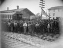
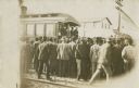
| Date: | |
|---|---|
| Description: | Crowd at station listening to a whistle-stop speaker at the railroad station, probably William McKinley. |

| Date: | 1914 |
|---|---|
| Description: | Includes index of University of Wisconsin buildings, churches, and public buildings. Top of Map reads: '"GET A SQUARE DEAL" AT THE COLLEGE BOOK STORE SHOWN... |

| Date: | 1886 |
|---|---|
| Description: | A hand-colored map of Milwaukee County, Wisconsin that shows the township and range system, sections, towns, roads, railroads and rail stations, cities and... |

| Date: | 1891 |
|---|---|
| Description: | A hand-colored map of Milwaukee County, Wisconsin that shows the township and range system, sections, towns, roads, railroads and rail stations, cities and... |
| Date: | 1990 |
|---|---|
| Description: | Text on reverse reads: "C.M.ST.P. & P. Depot, Stoughton, Wisconsin. A Craftsman style structure built in 1913, it was abandoned by the railway in the 1970'... |
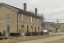
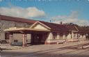
| Date: | 02 23 2012 |
|---|---|
| Description: | Exterior view of the railroad depot building. |

| Date: | 1902 |
|---|---|
| Description: | A map of Milwaukee County, Wisconsin that shows the township and range system, sections, towns, roads, railroads and rail stations, cities and villages, po... |
| Date: | |
|---|---|
| Description: | Crowd at railroad station listening to a whistle-stop speaker standing on the back of a caboose. Probably William McKinley. |
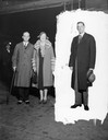
| Date: | 10 07 1930 |
|---|---|
| Description: | United States Secretary of the Interior Ray Lyman Wilbur and his wife at the Northwest railroad station, with an unidentified man isolated by a masked back... |
| Date: | |
|---|---|
| Description: | Train depot with a boy standing between the building and the railroad tracks. There are two doors marked "Men" and "Women". Four men can be seen on the rig... |

| Date: | 1950 |
|---|---|
| Description: | Subject: "Railroads — TD-9." Where Taken: "MidW." Information with photograph reads: "C.B.& Q. RR TD-9 with Hough bulldozer shovel repairing pavement of ya... |
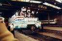
| Date: | 10 30 1989 |
|---|---|
| Description: | Wisconsin Governor Tommy G. Thompson, a member of the Amtrak governing board, joins an unidentified Amtrak official as the train breaks a ceremonial banner... |

| Date: | 1898 |
|---|---|
| Description: | Map showing the contour depths of the lakes in northwestern Waukesha County, Wisconsin. Roads, railroads, depots, churches, schools, and hotels in the area... |

| Date: | |
|---|---|
| Description: | View from side of railroad tracks of a train at the depot. A few men stand on the platform, and a man is pulling a luggage cart. |
If you didn't find the material you searched for, our Library Reference Staff can help.
Call our reference desk at 608-264-6535 or email us at: