 Search: public
Filter: Subject of resorts
Search: public
Filter: Subject of resorts

| Date: | 1961 |
|---|---|
| Description: | This map shows the lake, clubs, resorts, motels, school house, public approaches, and public parks. The back of map includes advertisements and text. |

| Date: | 1975 |
|---|---|
| Description: | This map shows nature trails, public attractions, public hunting and fishing grounds, dams, waysides, lakes, highways, and roads. The upper right corner in... |

| Date: | 1969 |
|---|---|
| Description: | This map shows businesses, resorts, roads, public boat landings, schools, cemeteries, and location of fish and game. An inset map reads: Continuation along... |

| Date: | 1991 |
|---|---|
| Description: | This map shows public access, fish crib locations, resorts, and other local businesses as well as advertisements for local attractions and a resort index. ... |

| Date: | 1991 |
|---|---|
| Description: | This 1991 map of Burnett County, Wisconsin, shows Governor Knowles State Forest, wildlife areas, public hunting grounds, and other outdoor recreation facil... |

| Date: | 1960 |
|---|---|
| Description: | This map shows public boat ramps, parks, highways, beaches, bluffs, Green Bay, Garrett Bay, Europe Bay and Lake, Rowley's Bay and Ellison Bay. The map incl... |

| Date: | 1891 |
|---|---|
| Description: | A hand-colored map of Milwaukee County, Wisconsin that shows the township and range system, sections, towns, roads, railroads and rail stations, cities and... |
| Date: | 1963 |
|---|---|
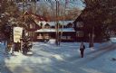
| Description: | Text on reverse reads: "Hotel du Nord, Sister Bay, Wisconsin 54234, Phone (414)854-4221. Winter Scene. AAA. Modern lodge rooms and cottages, all with priva... |

| Date: | 1994 |
|---|---|
| Description: | This map shows historical sites, picnic grounds, public boat landings, canoe and motor boat trips, and resort locations. The left margin of the map include... |
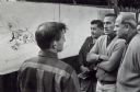
| Date: | 10 1968 |
|---|---|
| Description: | During a visit to Menominee County, Secretary of the Interior Stuart Udall and Senator Gaylord Nelson learn about a proposed resort complex. |
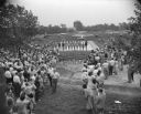
| Date: | 06 19 1949 |
|---|---|
| Description: | Elevated view of crowd at E.H. Myrland's Farm's Sky Lodge at the bathing beauty contest at the dedication of a new swimming pool at the resort which opened... |

| Speakers Bureau |
|---|
| Jim Draeger is a WHS Press author and member of the Wisconsin Historical Society Speakers Bureau. |
If you didn't find the material you searched for, our Library Reference Staff can help.
Call our reference desk at 608-264-6535 or email us at: