Search: public
Filter: Subject of state parks and reserves
Search: public
Filter: Subject of state parks and reserves

| Date: | 1939 |
|---|---|
| Description: | This nine-part map from the U.S. Bureau of Public Roads identifies federal and state highways in Wisconsin by pavement type. County, forest, park, and publ... |

| Date: | 1968 |
|---|---|
| Description: | The map shows fire towers, public camp grounds, roads, snow mobile & riding trails, trout lakes, foot trails, railroads, and National Forest boundaries. |

| Date: | 1944 |
|---|---|
| Description: | This nine-part map from the U.S. Bureau of Public Roads identifies federal and state highways in Wisconsin by pavement type. County, forest, park, and publ... |

| Date: | 1991 |
|---|---|
| Description: | This 1991 map of Burnett County, Wisconsin, shows Governor Knowles State Forest, wildlife areas, public hunting grounds, and other outdoor recreation facil... |
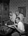
| Date: | 08 04 1949 |
|---|---|
| Description: | Looking over Governor Nelson Dewey's account books at the governor's desk in his office at Stonefield are Raymond Sivesind, state supervisor of historic si... |

| Date: | |
|---|---|
| Description: | Aerial view of Potawatomi State Park, with the Sturgeon Bay shoreline in the background. |
| Date: | 06 06 1953 |
|---|---|
| Description: | The official opening of Wade House. Amid great fanfare, complete with an appearance by poet Carl Sandburg, Wade House opened to the public on June 6th, 195... |
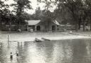
| Date: | |
|---|---|
| Description: | The bathhouse and wooden boardwalks at the swimming beach, Terry Andrae State Park. |
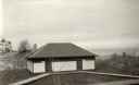
| Date: | |
|---|---|
| Description: | The office and administration building at Devil's Lake State Park. A car is parked outside of the building along the road. |

| Date: | 04 1932 |
|---|---|
| Description: | This Wisconsin Conservation Department map shows federal, state, and county forest areas, the relative proportion of land owned by each agency, and state p... |

| Date: | 1966 |
|---|---|
| Description: | This map includes a red overprint on base map and shows the supervisors and district numbers of St. Croix County. Includes diagrams of civil towns, townsh... |

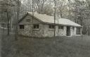
| Date: | |
|---|---|
| Description: | An interior view of the shelter house in Terry Andrae Park, including a stone fireplace. Terry Andrae is one part of the Kohler-Andrae Park system. |
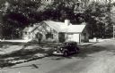
| Date: | 1940 |
|---|---|
| Description: | Several small groups of people are scattered about the roadside park among picnic tables. There are parked automobiles, and a small building. |
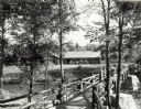
| Date: | 1940 |
|---|---|
| Description: | People on a rustic bridge over river at Copper Falls State Park. A long log building is in the background on the other side of the river. |
| Date: | 07 1940 |
|---|---|
| Description: | The bathing beach and bath house at Copper Falls State Park. Two swimmers are sitting and standing on a dock with a platform. |
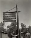
| Date: | |
|---|---|
| Description: | Two men are holding onto the newly installed directional sign at Terry Andrae State Park. There is a building on the left. The park was established in 1927... |
| Date: | 1938 |
|---|---|
| Description: | View of the new bath house at Devil's Lake State Park, taken from the pier. Two small boats are pulled up to the shore and two girls are wading in the wate... |
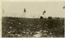
| Date: | 1914 |
|---|---|
| Description: | A view of the Lake Tomahawk ranger station taken about 1914 when the buildings were new. Shows the ranger's residence, water tower, the barn for horses wit... |
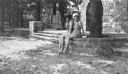
| Date: | 1935 |
|---|---|
| Description: | Two women in bathing suits and wearing brimmed hats are posing sitting on a stone wall. The description on the reverse of the print reads: "Two fair bather... |
If you didn't find the material you searched for, our Library Reference Staff can help.
Call our reference desk at 608-264-6535 or email us at: