 Search: public
Filter: Subject of wisconsin river (wis.)
Search: public
Filter: Subject of wisconsin river (wis.)

| Date: | 1868 |
|---|---|
| Description: | Bird's-eye map of Portage, with insets of the Court House and the Public School. |

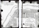
| Date: | 01 01 1856 |
|---|---|
| Description: | This map is mounted on cloth and shows lots, as well as location of the public square and college. Streets are labeled as is the Wisconsin River. |

| Date: | 1987 |
|---|---|
| Description: | This pictorial map shows roads, bridges, local businesses with phone numbers, and public buildings. Relief is shown pictorially. Also included is a calen... |

| Date: | 11 1836 |
|---|---|
| Description: | This map is pen-and-ink on paper and is a plat of a paper city on the Wisconsin River, in what is now the Town of Dekorra. The map shows lot and block numb... |
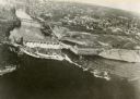
| Date: | 1940 |
|---|---|
| Description: | Aerial view of the Wisconsin Power and Light Company generating plant and dam. |
| Date: | 1900 |
|---|---|
| Description: | This map shows lots, public squares, landing, streets, and promenade of a paper city on a site now in the Town of West Point, Columbia County. The Wisconsi... |

| Date: | 1930 |
|---|---|
| Description: | Aerial view of Wisconsin Dells including the Wisconsin River and the dam and generating power plant. |

| Date: | |
|---|---|
| Description: | Carson Gulley and Louie Shepard cooking out along the Wisconsin River at Prairie du Sac. |

| Date: | |
|---|---|
| Description: | Exterior of the Consolidated Water Power and Paper Company, built in 1918. The view from across the Wisconsin River shows the company building, a dam, as w... |

| Date: | 1869 |
|---|---|
| Description: | Birds-eye drawing of Boscobel, Grant County, depicts street names and street layouts, houses, rivers and trees. A reference key at the bottom of the map sh... |

| Date: | 1846 |
|---|---|
| Description: | A map of Wisconsin and a portion of Minnesota that show the township surveys in progress in portions of the Saint Croix River region and in central Wiscons... |

| Date: | 1870 |
|---|---|
| Description: | Sauk City is the oldest incorporated village in Wisconsin (incorporated in 1854) and also has the oldest organized volunteer fire department in the state, ... |
If you didn't find the material you searched for, our Library Reference Staff can help.
Call our reference desk at 608-264-6535 or email us at: