 Search: spooner
Filter: Subject of water
Search: spooner
Filter: Subject of water
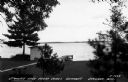
| Date: | 1935 |
|---|---|
| Description: | View of Spooner Lake from Jones Cottages. Caption reads: "Spooner Lake from Jones Cottages Spooner, Wis." |

| Date: | 1935 |
|---|---|
| Description: | View of the State Fish Hatchery with a boat in the foreground. Caption reads: "View at State Fish Hatchery Spooner, Wis." |
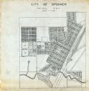
| Date: | 1900 |
|---|---|
| Description: | This map is ink on tracing paper and shows the city of Spooner. The map shows numbered plats, labeled streets, and the Yellow River. |

| Date: | |
|---|---|
| Description: | Fisherman cooking on campfire at the edge of a river. |

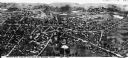
| Date: | 1960 |
|---|---|
| Description: | Text on front reads: "Greetings from Spooner, Wis." Text on reverse: "Looking north on this aerial view one can see the State Fish Hatchery in the foregrou... |
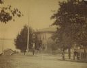
| Date: | 1875 |
|---|---|
| Description: | View of the Spooner residence on the south corner of Wilson and Carroll Streets, with the lake in the background. This was the home of John C., Phil H., an... |

| Date: | 1941 |
|---|---|
| Description: | This 1941 map covers Washburn County, Wisconsin, as well as western Sawyer, eastern Burnett, and northeastern Polk counties. It shows the locations of tour... |
| Date: | |
|---|---|
| Description: | Bird's-eye drawing of town, with an inset at bottom center of the Soldiers' Monument. Caption reads, "Bird's-eye view of Village of Barre, Mass." |
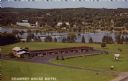
| Date: | 1963 |
|---|---|
| Description: | Text on front reads: "Country House Motel." On reverse: "Country House Motel. Northwest's Finest - Highways 53 and 63. Room Phones - Color TV - Air-Conditi... |

| Date: | 1909 |
|---|---|
| Description: | This 1909 revision of Harmon's 1896 map of Washburn County, Wisconsin, shows the township and range grid, towns, sections, schools, wagon roads, cities and... |

| Date: | 1943 |
|---|---|
| Description: | This map shows roads, trails, taverns, schools, golf, gas stations, campsites, resorts, and towers. The lower left of the map includes a legend. The map co... |
If you didn't find the material you searched for, our Library Reference Staff can help.
Call our reference desk at 608-264-6535 or email us at: