 Search: transportation
Search: farms
Filter: Categories of Wisconsin Historical Images
Filter: Creator Name of Vinje, Arthur M., 1888-1972
Search: transportation
Search: farms
Filter: Categories of Wisconsin Historical Images
Filter: Creator Name of Vinje, Arthur M., 1888-1972
| Date: | 01 30 1949 |
|---|---|
| Description: | Aerial view of town, with a large building on a town square in the center. The edges of town are bordered by fields and farms. |

| Date: | 11 1928 |
|---|---|
| Description: | Aerial view residential areas of Windsor and the surrounding countryside. |

| Date: | 11 17 1947 |
|---|---|
| Description: | The farm of the Pomputis family near Longwood, where Sennett and Winslow hid out and were captured. |

| Date: | 11 1928 |
|---|---|
| Description: | Aerial view of Verona including businesses, houses, and the surrounding farm land. |

| Date: | 11 1928 |
|---|---|
| Description: | Aerial view of Black Earth residential area and the surrounding countryside. |

| Date: | 11 1928 |
|---|---|
| Description: | Aerial view of Cross Plains, including residences and the surrounding countryside. |

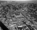
| Date: | 10 1928 |
|---|---|
| Description: | Aerial view of Sun Prairie, including the central business district, residences, and the surrounding countryside stretching to the horizon. |
| Date: | 05 24 1947 |
|---|---|
| Description: | Governor Oscar Rennebohm farm, on U.S. Highway 151, five miles east of the Capitol between Madison and Sun Prairie. Shows the barn and bungalow intended fo... |
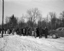
| Date: | 11 17 1947 |
|---|---|
| Description: | Neighbors of the Pomputis family and newspaper reporters wait on a highway near the farm where the confessed murderers were hiding. |
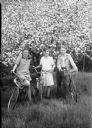
| Date: | 05 18 1944 |
|---|---|
| Description: | Carolyn Hall, Bruce Mohs, and David Culver, with bicycles, at the Youth Hostel on the Samuel Post farm, located on Middleton Road, near Shorewood Hills. |
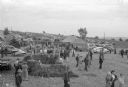
| Date: | 09 27 1945 |
|---|---|
| Description: | Exhibit of new machinery at the terrace plowing demonstration and conservation field day on the Carl Ribbke farm near Ableman. Some of the 2,000 cars and b... |
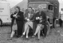
| Date: | 09 27 1945 |
|---|---|
| Description: | Three farm wives are taking a break at the terrace plowing demonstration and conservation field day on the Carl Ribbke farm near Ableman. From left are Mr... |

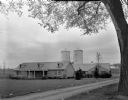
| Date: | 10 08 1945 |
|---|---|
| Description: | A barn on the Quaker Oats farm on 4202 Monona Drive. A sign above the barn door reads: "Branch Warehouse of William Le[?] Warehouses, Public Bonded Warehou... |

| Date: | 02 25 1959 |
|---|---|
| Description: | Winter scene with garagemen retrieving another car from the open drainage ditch on Midvale Boulevard. The 1959 Dodge skidded into a snowbank and catapulted... |

| Date: | 11 1953 |
|---|---|
| Description: | A group of Lapham School third grade children are lining up to begin a tour of the Bowman Farm Dairy on Fish Hatchery Road. At the head of the line are Geo... |

| Date: | 10 09 1957 |
|---|---|
| Description: | View of the John Castle dairy farm, located off North Sherman Avenue near Darwin Road. The barn has its wall boards removed revealing a wood beam frame, a ... |
If you didn't find the material you searched for, our Library Reference Staff can help.
Call our reference desk at 608-264-6535 or email us at: