 Search: transportation
Search: farms
Filter: Categories of Wisconsin Historical Images
Filter: Community of Madison
Search: transportation
Search: farms
Filter: Categories of Wisconsin Historical Images
Filter: Community of Madison
| Date: | 09 1958 |
|---|---|
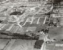
| Description: | University Hill Farms from an aerial perspective. |

| Date: | 1922 |
|---|---|
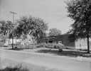
| Description: | University of Wisconsin-Madison road near University Farms. There are cows in a field on the right. |
| Date: | 1962 |
|---|---|
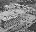
| Description: | Aerial view of the Hill Farms State Office Building, 4802 Sheboygan Avenue, during construction. |

| Date: | 01 31 1964 |
|---|---|
| Description: | Aerial view of University Hill Farms area which has grown from a cow pasture to a square-mile housing and business area. 4,000 people live in 750 single-fa... |
| Date: | 05 02 1935 |
|---|---|
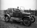
| Description: | 1915 model Ford truck, with driver, in a farm yard. |
| Date: | 06 20 1931 |
|---|---|
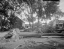
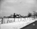
| Description: | Trees blown over by windstorm, at the Edward Korb farm, Route 1, Waunakee Road. |

| Date: | 04 03 1962 |
|---|---|
| Description: | View looking south from the Shorewood bluff of the Hilldale Shopping Center under construction. Apartments and houses in the Hill Farms neighborhood are in... |
| Date: | 03 04 1932 |
|---|---|
| Description: | Piper Brothers farm scene, 4718 Odana Road near Midvale. |
| Date: | 09 14 1932 |
|---|---|
| Description: | View across road towards the Bowman dairy and farm on Fish Hatchery Road. |

| Date: | |
|---|---|
| Description: | View from roadside, with a tree in the foreground, towards a field with haystacks, and farm buildings in the distance among trees. |

| Date: | 1960 |
|---|---|
| Description: | Aerial view of rural landscape with suburban construction in foreground. Cottage Grove Road is at left with the newly constructed Acewood Boulevard crossin... |
| Date: | 1924 |
|---|---|
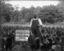
| Description: | A middle-aged man stands holding an agricultural implement in a field of tobacco plants. A sign next to him reads: "We Are Power Farmers Using Fordson Trac... |

| Date: | 1962 |
|---|---|
| Description: | Aerial view of the Hilldale Shopping Center and environs. Anchor store is Gimbels. N. Midvale Boulevard runs left to right. The State Department of Transpo... |

| Date: | |
|---|---|
| Description: | View from road, with the front of an automobile on the right, towards a farm. Cows and pigs are in a pasture, and two silos are next to the barn. |
| Date: | 05 24 1947 |
|---|---|
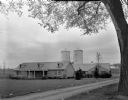
| Description: | Governor Oscar Rennebohm farm, on U.S. Highway 151, five miles east of the Capitol between Madison and Sun Prairie. Shows the barn and bungalow intended fo... |
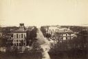
| Date: | 1887 |
|---|---|
| Description: | Elevated view of Wisconsin Avenue from the Wisconsin State Capitol building. Mansions and churches are along the road, and Lake Mendota and Picnic Point ar... |

| Date: | 1947 |
|---|---|
| Description: | View across farmyard towards a man working with a No. 2 ensilage and forage blower near a barn and two silos. Bowman dairy farm. |

| Date: | 1956 |
|---|---|
| Description: | Aerial view over University Avenue of the University of Wisconsin-Madison campus, including University farm in the upper middle. The shoreline of Lake Mend... |
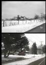
| Date: | |
|---|---|
| Description: | A vintage view and a modern view of 4718 Odana Road, presented as a pair. The vintage view shows the Piper Brothers Farm. The modern view shows a house wit... |
If you didn't find the material you searched for, our Library Reference Staff can help.
Call our reference desk at 608-264-6535 or email us at:
