 Search: transportation
Search: farms
Filter: Categories of Wisconsin Historical Images
Filter: County of Dane
Search: transportation
Search: farms
Filter: Categories of Wisconsin Historical Images
Filter: County of Dane
| Date: | 09 1958 |
|---|---|
| Description: | University Hill Farms from an aerial perspective. |

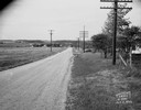
| Date: | 1922 |
|---|---|
| Description: | University of Wisconsin-Madison road near University Farms. There are cows in a field on the right. |
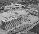
| Date: | 1962 |
|---|---|
| Description: | Aerial view of the Hill Farms State Office Building, 4802 Sheboygan Avenue, during construction. |
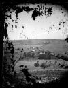
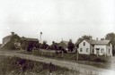
| Date: | 1873 |
|---|---|
| Description: | View of several farms, including Burton's, Fitlen's and Rustebakke's. Field arrangements and fencing patterns are evident. A man is walking along the bott... |

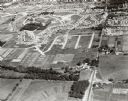
| Date: | 01 31 1964 |
|---|---|
| Description: | Aerial view of University Hill Farms area which has grown from a cow pasture to a square-mile housing and business area. 4,000 people live in 750 single-fa... |
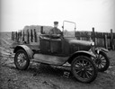
| Date: | 05 02 1935 |
|---|---|
| Description: | 1915 model Ford truck, with driver, in a farm yard. |

| Date: | 05 28 1961 |
|---|---|
| Description: | Landscape view of a rolling countryside. A farm is visible in the distance. |
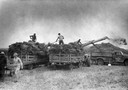
| Date: | 1950 |
|---|---|
| Description: | A stationary McCormick-Deering thresher in action at the E.J. Shuster Farm. |
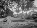
| Date: | 06 20 1931 |
|---|---|
| Description: | Trees blown over by windstorm, at the Edward Korb farm, Route 1, Waunakee Road. |

| Date: | 1955 |
|---|---|
| Description: | Aerial view of Cross Plains, with countryside surrounding and hills on the horizon. |
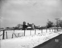
| Date: | 10 11 1949 |
|---|---|
| Description: | Buckeye Road accident scene, looking north near Homburg farm, 3976 County Trunk Highway AB. |
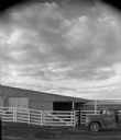
| Date: | 10 1966 |
|---|---|
| Description: | A pickup is parked outside two agricultural buildings on a dairy farm. A white fence encloses the two buildings. |

| Date: | 04 03 1962 |
|---|---|
| Description: | View looking south from the Shorewood bluff of the Hilldale Shopping Center under construction. Apartments and houses in the Hill Farms neighborhood are in... |
| Date: | 1912 |
|---|---|
| Description: | Exterior of the Droster farm located on Felland Road. The house was built in 1854. |

| Date: | 1925 |
|---|---|
| Description: | Elevated view of Mount Vernon from the a grassy hill. |
| Date: | 03 04 1932 |
|---|---|
| Description: | Piper Brothers farm scene, 4718 Odana Road near Midvale. |

| Date: | 11 1928 |
|---|---|
| Description: | Aerial view residential areas of Windsor and the surrounding countryside. |
If you didn't find the material you searched for, our Library Reference Staff can help.
Call our reference desk at 608-264-6535 or email us at:


