 Search: transportation
Search: farms
Filter: Categories of Wisconsin Historical Images
Filter: Subject of farms
Search: transportation
Search: farms
Filter: Categories of Wisconsin Historical Images
Filter: Subject of farms

| Date: | 1922 |
|---|---|
| Description: | University of Wisconsin-Madison road near University Farms. There are cows in a field on the right. |
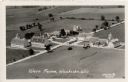
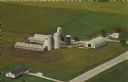
| Date: | 1931 |
|---|---|
| Description: | Aerial view of a farm complex, including a farmhouse and several large buildings. Caption reads: "Wern Farms, Waukesha, Wis." |

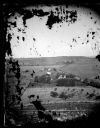
| Date: | 1955 |
|---|---|
| Description: | Elevated view from a hill towards a valley with several farms and fields. A forested hill is in the far background. |
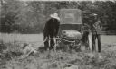
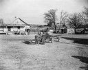
| Date: | 1915 |
|---|---|
| Description: | At Cornfalfa Farms two men try automobile exhaust to deal with their woodchuck problem. |
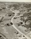
| Date: | |
|---|---|
| Description: | Aerial view of a road, with several farms, fields and hills along it. Caption reads: "U.S. 16 near La Crosse, Wis." |
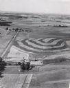
| Date: | 1956 |
|---|---|
| Description: | Aerial view of contour farming. Farms and patches of woods are spread out in the landscape. |

| Date: | |
|---|---|
| Description: | Map shows roads, railroads, rivers, and improved farms. Includes text on lands for sale and exchange by B.W. Pulling, successor to Marshfield Land Company.... |

| Date: | 1919 |
|---|---|
| Description: | Two International model "F" or "31" trucks operated for Geo. E. Morse Farms of Ladora. Both trucks are driven by male drivers on a dirt road leading from a... |

| Date: | 1929 |
|---|---|
| Description: | Elevated view of Viola and neighboring farms in a valley surrounded by rolling hills. |

| Date: | 1876 |
|---|---|
| Description: | Map shows townships and sections, landownership and acreages, roads, railroads, post offices, and farms. Sections appear in pink, yellow, and blue. On the ... |

| Date: | 1966 |
|---|---|
| Description: | Overgrown farmstead on County Highway N in Marathon County. |
| Date: | 1947 |
|---|---|
| Description: | African American farmer pulling a trailer with a Farmall Cub tractor on McQueen Smith Farms. The trailer is loaded with large sacks, and a child is sitting... |
| Date: | 1873 |
|---|---|
| Description: | View of several farms, including Burton's, Fitlen's and Rustebakke's. Field arrangements and fencing patterns are evident. A man is walking along the bott... |

| Date: | 1943 |
|---|---|
| Description: | This photocopy map shows inhabited farms, rivers, roads, and mills in the vicinity of Marathon City [and village of Edgar], including area between the Big ... |

| Date: | 1904 |
|---|---|
| Description: | Map shows townships and sections, landownership and acreages, roads, railroads, post offices, and farms. On the top, bottom, and sides of map are advertise... |
| Date: | 12 14 1972 |
|---|---|
| Description: | Text on the reverse reads: "Mayer Farms. Dick and Fritz Mayer Families. Registered Holsteins. Visitors Always Welcome. Located 2 miles south of Slinger, Wi... |
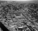
| Date: | 01 30 1949 |
|---|---|
| Description: | Aerial view of town, with a large building on a town square in the center. The edges of town are bordered by fields and farms. |
If you didn't find the material you searched for, our Library Reference Staff can help.
Call our reference desk at 608-264-6535 or email us at:


