 Search: transportation
Search: farms
Filter: Categories of Wisconsin Historical Images
Filter: Year of 1900-1999
Filter: Creator Name of Unknown
Search: transportation
Search: farms
Filter: Categories of Wisconsin Historical Images
Filter: Year of 1900-1999
Filter: Creator Name of Unknown

| Date: | 1922 |
|---|---|
| Description: | University of Wisconsin-Madison road near University Farms. There are cows in a field on the right. |
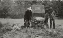
| Date: | 1915 |
|---|---|
| Description: | At Cornfalfa Farms two men try automobile exhaust to deal with their woodchuck problem. |
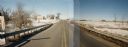
| Date: | 03 03 1988 |
|---|---|
| Description: | View from bridge over Wild Creek on Marathon County Highway M. The creek appears frozen, although in flood. Several farms can be seen in the distance. |

| Date: | 1966 |
|---|---|
| Description: | Overgrown farmstead on County Highway N in Marathon County. |
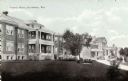
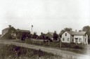
| Date: | 1920 |
|---|---|
| Description: | View across lawn towards buildings. Caption reads: "County Farm, Reedsburg, Wis." |

| Date: | 1912 |
|---|---|
| Description: | A plat map of the township of West Kewaunee. |

| Date: | 1910 |
|---|---|
| Description: | This map shows the locations of school houses, farms, roads, railroads, and Bad River Indian Reservation. Relief is shown by hachures. Yellow and red manus... |

| Date: | 1969 |
|---|---|
| Description: | A pea combine in use on an unidentified Wisconsin farm. |
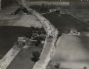
| Date: | 1935 |
|---|---|
| Description: | Aerial view of the paving operation of Joseph D. Bonners, Inc., on St. Martins Road at Hales Corners. |
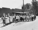
| Date: | 08 1957 |
|---|---|
| Description: | Women workers on strike against the Holly Farms Poultry Company, posed outside for a "solidarity" picture. Dorothy Johnson, wearing the third picket sign f... |
| Date: | 1912 |
|---|---|
| Description: | Exterior of the Droster farm located on Felland Road. The house was built in 1854. |
| Date: | 1949 |
|---|---|
| Description: | Susanne Hafner Goldfarb and unidentified friend ride in a cart pulled by a mule; Raanana, Israel. |

| Date: | 1915 |
|---|---|
| Description: | This map shows school houses, churches, farms, and railroads. Chequamecon Bay and Bad River Indian Reservation are labeld. The map reads: "All lands shown ... |
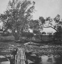
| Date: | 1920 |
|---|---|
| Description: | View of pasture land, with a bit of the Lake Koshkonong in the foreground, a wooden dock that is little more than planks, and several kayaks docked. |
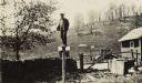
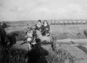
| Date: | 05 19 1929 |
|---|---|
| Description: | Bernard Arms stands atop a post on a farm. |

| Date: | 1956 |
|---|---|
| Description: | Lewis Arms sits on the trunk of a 1949 convertible (DeSoto?) automobile, strumming a guitar. |

| Date: | 1933 |
|---|---|
| Description: | Three hogs feed on the Larson farm. There are farm wagons in the background and snow on the ground. |

| Date: | 03 1963 |
|---|---|
| Description: | Panoramic landscape view of the Fey Farm near Dexterville, Wood County. The view incudes the farmstead and much of the surrounding acreage and woodlands. T... |

| Date: | 1915 |
|---|---|
| Description: | Low perspective of a dirt country road curving into the distance. The road is bordered by fields and scattered wooden buildings while a solitary figure ap... |
If you didn't find the material you searched for, our Library Reference Staff can help.
Call our reference desk at 608-264-6535 or email us at:
