 Search: voting
Filter: Subject of persons
Filter: Type of Map or Atlas
Search: voting
Filter: Subject of persons
Filter: Type of Map or Atlas
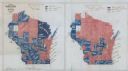
| Date: | 1900 |
|---|---|
| Description: | Hand-drawn and colored maps of Wisconsin showing how each county voted in the gubernatorial race of 1865, and on a referendum regarding suffrage for Africa... |

| Date: | 1860 |
|---|---|
| Description: | This map of Dodge County, Wisconsin, shows the township and range grid, towns, sections, cities and villages, railroads, roads, property owners and acreage... |
If you didn't find the material you searched for, our Library Reference Staff can help.
Call our reference desk at 608-264-6535 or email us at: