Search: wisconsin
Filter: Type of Photograph
Filter: Subject of human settlements
Filter: Subject of croplands
Search: wisconsin
Filter: Type of Photograph
Filter: Subject of human settlements
Filter: Subject of croplands

| Date: | 1956 |
|---|---|
| Description: | Aerial view of upper campus of the University of Wisconsin-Madison with Lake Mendota. |

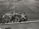
| Date: | 1958 |
|---|---|
| Description: | The Schuepbach Farm off East Clayton Road, with a view of the Wisconsin State Capitol in the far distance. |
| Date: | |
|---|---|
| Description: | View up hill of Washburn Observatory on the University of Wisconsin-Madison campus. The President's residence and a rear view of Bascom Hall are to the rig... |
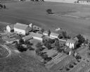
| Date: | 1946 |
|---|---|
| Description: | Aerial view of farm which is part of the University of Wisconsin-Madison. In the foreground is a tree-lined road. The farm has several buildings, including... |

| Date: | 1964 |
|---|---|
| Description: | Farm scene along County Trunk Highway M. A horse is grazing in a harvested cornfield near a barn. |
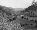
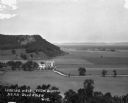
| Date: | 1953 |
|---|---|
| Description: | View from hill towards a farm nestled in a valley. Trees dot the slopes, and woods cover the tops of the hills. |
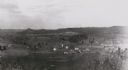
| Date: | 1880 |
|---|---|
| Description: | Elevated view from hill towards farm fields and houses. Tree-covered hills are in the distance. |
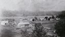
| Date: | 1900 |
|---|---|
| Description: | Elevated view from hill towards farm fields and houses in Oil City. Tree-covered hills are in the distance. |
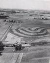
| Date: | 1956 |
|---|---|
| Description: | Aerial view of contour farming. Farms and patches of woods are spread out in the landscape. |
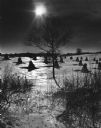
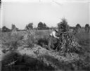
| Date: | 1969 |
|---|---|
| Description: | Shocks of corn or grain standing in a snow-covered field. A lone tree and foliage is in the foreground. More trees and a fence are in the background. The s... |
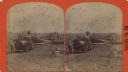
| Date: | |
|---|---|
| Description: | Stereograph of farmers using a thresher powered by a steam driven tractor. Church steeples of Monroe are on the horizon on the left. Hand-written on revers... |

| Date: | 1965 |
|---|---|
| Description: | Elevated view of roads, railroad tracks, building, farm fields, and a body of water. |
| Date: | |
|---|---|
| Description: | A bird's-eye view of a farmland property with barns and farmhouse. |
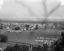
| Date: | 1913 |
|---|---|
| Description: | Bird's-eye view of the village. Cropland and barns cover much of the landscape. |

| Date: | |
|---|---|
| Description: | View from hill over church and cemetery towards fields and town in a valley. |
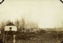
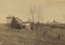
| Date: | 1935 |
|---|---|
| Description: | View of the dilapidated farm from which the Brundage family moved with the assistance of The United States Resettlement Administration. |

| Date: | |
|---|---|
| Description: | View from road of a stone one-room school house and shed. In the background is a field and farm buildings. |
If you didn't find the material you searched for, our Library Reference Staff can help.
Call our reference desk at 608-264-6535 or email us at: