 Search: wisconsin
Filter: Type of Photograph
Filter: Subject of land use, urban
Filter: Subject of intellectual life
Search: wisconsin
Filter: Type of Photograph
Filter: Subject of land use, urban
Filter: Subject of intellectual life

| Date: | 1930 |
|---|---|
| Description: | Aerial view of the University of Wisconsin-Madison campus including Camp Randall Stadium, the Wisconsin State Capitol, and both Lake Mendota and Lake Monon... |

| Date: | 1922 |
|---|---|
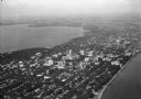
| Description: | Aerial view of the Wisconsin State Capitol and Lake Monona. |

| Date: | 1930 |
|---|---|
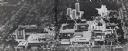
| Description: | Aerial view of the Wisconsin State Capitol and the surrounding businesses. |

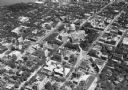
| Date: | 1930 |
|---|---|
| Description: | Aerial view of the Wisconsin State Capitol and the surrounding businesses. |

| Date: | 08 20 1930 |
|---|---|
| Description: | Aerial view of the Madison skyline from University of Wisconsin Field House, overlooking the Wisconsin State Capitol and, in the foreground, Gateway Lumber... |

| Date: | 1930 |
|---|---|
| Description: | Aerial view of the University of Wisconsin-Madison campus, the State Historical Society of Wisconsin building, Lake Mendota, residential areas and the surr... |

| Date: | 1930 |
|---|---|
| Description: | Aerial view of the Wisconsin State Capitol, the surrounding businesses, and Lake Monona. |
| Date: | |
|---|---|
| Description: | Aerial view of downtown area featuring the Wisconsin State Capitol. |

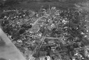
| Date: | 03 16 1949 |
|---|---|
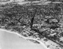
| Description: | Aerial view of Mauston, Wisconsin. |
| Date: | 1925 |
|---|---|
| Description: | Aerial photograph taken as part of a survey by the Wisconsin Power and Light Company to promote economic development by emphasizing available buildings and... |

| Date: | 1926 |
|---|---|
| Description: | Originally titled 'Recent Aeroplane View of University Campus', the view of the Wisconsin Historical Society, the Red Gym, Science Hall and Bascom Hall wit... |

| Date: | 1928 |
|---|---|
| Description: | University of Wisconsin-Madison, looking west. Lake Mendota and Picnic Point are in the upper right of the image. Bascom Hall, the Red Gym, the Wisconsin H... |

| Date: | 1945 |
|---|---|
| Description: | View of the lower campus of the University of Wisconsin-Madison includes Bascom Hill, Wisconsin Historical Society, Memorial Union and the Armory (Red Gym ... |
| Date: | 1930 |
|---|---|
| Description: | Aerial view looking southeast, towards the city, including the Wisconsin State Capitol, the central business district, the Capitol Square, both Lake Mendot... |

| Date: | 1946 |
|---|---|
| Description: | University of Wisconsin-Madison campus, looking south from Lake Mendota. Camp Randall stadium is in the upper right. |
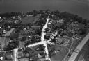
| Date: | |
|---|---|
| Description: | Aerial view of the town, including the Wisconsin River, and the surrounding countryside. |
| Date: | 1972 |
|---|---|
| Description: | Aerial view of Milwaukee campus, with surrounding homes and buildings. |

| Date: | 1947 |
|---|---|
| Description: | University of Wisconsin-Madison, from Park Street to the men's dormitories. Part of Lake Mendota is in the top right corner. |
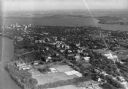
| Date: | 02 09 1949 |
|---|---|
| Description: | One of five aerial views of Portage, including the frozen Wisconsin River. |
| Date: | 1930 |
|---|---|
| Description: | Aerial view of the city, including the Isthmus, the Wisconsin State Capitol, the downtown business district, Lake Mendota, and Lake Monona. |
If you didn't find the material you searched for, our Library Reference Staff can help.
Call our reference desk at 608-264-6535 or email us at: