Visit our other Wisconsin Historical Society websites!
 Search: wisconsin
Filter: Type of Photograph
Filter: Subject of land use, urban
Search: wisconsin
Filter: Type of Photograph
Filter: Subject of land use, urban
| Date: | |
|---|---|
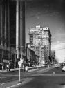
| Description: | Looking east on Wisconsin Avenue at Water Steet with cars and pedestrians. Streetcars are running up and down the middle of the wide street. Skyscrapers an... |
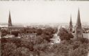
| Date: | 1905 |
|---|---|
| Description: | Elevated view down West Washington Avenue from the roof of the Wisconsin State Capitol. Three churches are seen, from left: St. Raphael Catholic Church, Fi... |

| Date: | |
|---|---|
| Description: | Elevated stereograph of the Northwestern Mutual Life Insurance Company Building on Broadway Street and Wisconsin Avenue. Horses and carriages are on the un... |
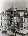
| Date: | 08 11 1927 |
|---|---|
| Description: | Elevated view of the Strand Theater located at 16 East Mifflin Street near the corner of Wisconsin Avenue. The marquee reads "Babe Ruth and Anna Q. Nilsson... |
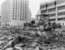
| Date: | 02 23 1978 |
|---|---|
| Description: | A Caterpillar bulldozer breaking ground for the construction of the State Natural Resources Building, also known as General Executive Facility (GEF) 2, and... |
| Date: | 1925 |
|---|---|
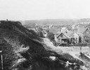
| Description: | Elevated view from a hill of an alley connecting Park Hill Avenue and Mount Vernon Avenue, looking west from the Interurban Line. There is a person on top ... |

| Date: | |
|---|---|
| Description: | John S. Fuller took this photographs of the buildings in the first block of East Main Street from the Wisconsin State Capitol roof. Most of the businesses ... |
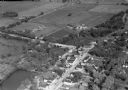
| Date: | 10 1928 |
|---|---|
| Description: | Aerial view of DeForest including residences and the surrounding countryside. |

| Date: | 10 1928 |
|---|---|
| Description: | Aerial view of Mount Horeb, including the central business district. |

| Date: | 08 1912 |
|---|---|
| Description: | Two African American men unloading the cement chute during paving of Janesville Plank Road. |

| Date: | 09 1972 |
|---|---|
| Description: | The Reierson Photography Studio storefront, in its new location, 14 East Mifflin Street, between adjoining businesses. The Wisconsin State Capitol is refle... |
| Date: | 1908 |
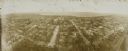
|---|---|
| Description: | Kite aerial panoramic photograph of the central business district. In the distance is Lake Mendota. The fire damaged Wisconsin State Capitol is in the cent... |

| Date: | 07 30 1918 |
|---|---|
| Description: | Elevated view of the Waldheim furniture building and surrounding commercial area on N. Plankinton Avenue, north of W. Wisconsin Avenue. The Waldheim Furnit... |
| Date: | 09 14 1913 |
|---|---|
| Description: | Looking northwest from the roof of Northwestern Mutual home office at E. Wisconsin Avenue and N. Van Buren Street toward City Hall, Milwaukee courthouse an... |

| Date: | 1935 |
|---|---|
| Description: | The Court of Honor, Wisconsin Avenue. The statue, "The Victorious Charge," is in the center, with a church behind. On the left are more buildings going int... |
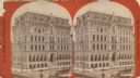
| Date: | 1890 |
|---|---|
| Description: | Stereograph; corner of Broad and Wisconsin Avenues. Built in 1870. E.T. Mix, architect. Victorian details decorate the six story building. A small pile of... |
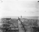
| Date: | 1898 |
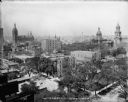
|---|---|
| Description: | Elevated view from the top of the Pabst Building down East Wisconsin Avenue all the way to Milwaukee Bay and out to the horizon of Lake Michigan. One of th... |
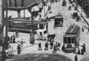
| Date: | 1901 |
|---|---|
| Description: | Elevated view of scene at the corner of Grand (Avenue?) and West Water Street, now Plankinton and Wisconsin Avenues. Several streetcars are in the streets ... |
| Date: | 10 1928 |
|---|---|
| Description: | Aerial view of Belleville, including the central business disctrict and the surrounding countryside. |

| Date: | 11 1928 |
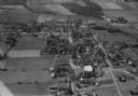
|---|---|
| Description: | Aerial view residential areas of Windsor and the surrounding countryside. |
If you didn't find the material you searched for, our Library Reference Staff can help.
Call our reference desk at 608-264-6535 or email us at: