 Search: wisconsin
Filter: Subject of breweries
Filter: Subject of human settlements
Search: wisconsin
Filter: Subject of breweries
Filter: Subject of human settlements
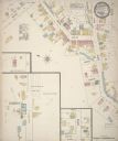
| Date: | 1884 |
|---|---|
| Description: | Sanborn map showing the main street of Potosi, Wisconsin, with an inset for the Potosi Brewery. |

| Date: | 1912 |
|---|---|
| Description: | Sanborn insurance map of the main street in Potosi, Wisconsin, with an inset for the Potosi Brewery. |

| Date: | 1870 |
|---|---|
| Description: | This 1870 map of Brown County, Wisconsin, shows the township and range grid, towns, sections, cities, villages and post offices, land ownership, roads, rai... |
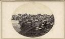
| Date: | 1862 |
|---|---|
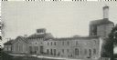
| Description: | John S. Fuller took this image of the third Wisconsin State Capitol (the second in Madison), from Governor Farwell's Octagon House, probably early in 1862.... |
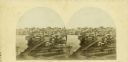
| Date: | 1862 |
|---|---|
| Description: | The third Wisconsin State Capitol (the second in Madison), from Governor Farwell's Octagon House, probably early in 1862. Also visible in the downtown are ... |
| Date: | 1935 |
|---|---|
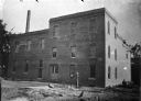
| Description: | The second brewery to be built in Wisconsin and the oldest still standing (at the time the photograph was taken). |
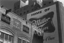
| Date: | 1977 |
|---|---|
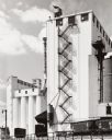
| Description: | Miller Brewery taken as part of a project to document the Wisconsin brewing industry. |
| Date: | |
|---|---|
| Description: | View of the area behind the Fauerbach brewery. There is a Wil Kil sign on the building on the left. The dome of the Wisconsin State Capitol can be seen on ... |
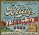
| Date: | 1933 |
|---|---|
| Description: | Label submitted to the state of Wisconsin for trademark registration. "Blatz, Old Heidelberg Castle, Beer, Blatz Brewing Co." Pictured on the label is a sc... |
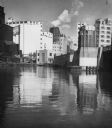
| Date: | 1955 |
|---|---|
| Description: | Industries along the Milwaukee River, one of which is the Schlitz Brewery. |
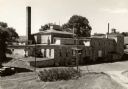
| Date: | |
|---|---|
| Description: | Exterior view of the original Oderbolz Brewery, southeast corner of Fourth Street and Pierce Street. Later Rock Spring Cold Storage. |

| Date: | 1891 |
|---|---|
| Description: | The index page of a Sanborn Map of Stevens Point. |
| Date: | 1899 |
|---|---|
| Description: | Exterior view of the Hausmann Brewing Company's Malt House, 1603 Sherman Avenue. |
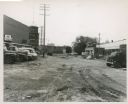
| Date: | 07 1952 |
|---|---|
| Description: | Train cars are parked near a tall building with a fire escape. |
| Date: | 07 03 1886 |
|---|---|
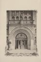
| Description: | The ornate entrance to the Schlitz Palm Garden. Located on N. 3rd Street, south of W. Wisconsin Avenue, the Schlitz Palm Garden opened on July 3, 1886 and ... |

| Date: | 1892 |
|---|---|
| Description: | A Sanborn fire insurance map of Sauk City which was drawn up in 1892. |

| Date: | 1915 |
|---|---|
| Description: | A Sanborn fire insurance map of Sauk City created in 1915. |

| Date: | 1900 |
|---|---|
| Description: | A Sanborn fire insurance map of Sauk City created in 1900. |

| Date: | 1933 |
|---|---|
| Description: | Label submitted to the State of Wisconsin for trademark registration. "Loewen Bräu (Lion Brew) Beer, United States Brewing Co." The label features the silh... |
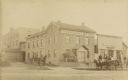
| Date: | 1885 |
|---|---|
| Description: | Exterior view of Fauerbach's Brewery at 651-53 Williamson Street. |
If you didn't find the material you searched for, our Library Reference Staff can help.
Call our reference desk at 608-264-6535 or email us at: