 Filter: Categories of Wisconsin Historical Images
Filter: Creator Name of Richter, Gustav
Filter: Categories of Wisconsin Historical Images
Filter: Creator Name of Richter, Gustav

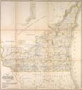
| Date: | 1849 |
|---|---|
| Description: | Published in Germany a year after Wisconsin entered statehood, this map shows prairies, swamps, lakes, mounds, limestone deposits, and lead and copper mine... |
| Date: | 1849 |
|---|---|
| Description: | Foldout map of southern Wisconsin. |
If you didn't find the material you searched for, our Library Reference Staff can help.
Call our reference desk at 608-264-6535 or email us at: