 Filter: Categories of Wisconsin Historical Images
Filter: Community of Green Bay
Filter: Year of 1800-1899
Filter: Categories of Wisconsin Historical Images
Filter: Community of Green Bay
Filter: Year of 1800-1899

| Date: | 1895 |
|---|---|
| Description: | Daniel H. and Joshua Whitney's residence located at 402 Main Street at the intersection of Monroe Avenue. The house was torn down in 1897. |

| Date: | 1821 |
|---|---|
| Description: | Plan of the settlement of Green Bay. |

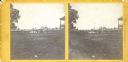
| Date: | 1895 |
|---|---|
| Description: | A man sits on a stool and milks a cow outdoors near a fence. Another cow investigates the camera lens in the foreground. |
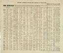
| Date: | 02 01 1864 |
|---|---|
| Description: | List of Civil War draft-dodgers issued by the Provost Marshal's office, Fifth District of Wisconsin. |

| Date: | 1896 |
|---|---|
| Description: | Railroad employees pose with locomotive engine no. 925 of the Chicago, Milwaukee & St. Paul Railway. The engine has a long pilot, a large oil headlight, sm... |

| Date: | 1835 |
|---|---|
| Description: | Ink on tracing paper map of Green Bay, Wisconsin and nearby areas, Lake Winnebago, Fox and Wolf Rivers, and the junctions of the Mississippi and Wisconsin ... |
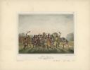
| Date: | 1842 |
|---|---|
| Description: | Menominee war dance, as depicted by Francois, Comte de Castelnau, a French naturalist and diplomat who visited Green Bay, Wisconsin about 1838. This detail... |
| Date: | 1853 |
|---|---|
| Description: | Stereograph of the interior of Fort Howard after its decommissioning in 1853. |

| Date: | 1816 |
|---|---|
| Description: | This is a photostat copy of a manuscript map in the National Archives showing a plan of Fort Howard and a view of its north side. Originally surveyed by Wi... |

| Date: | 1836 |
|---|---|
| Description: | This manuscript shows the 1835 survey of the road corresponding approximately to a portion of County Trunk A in the Town of Scott, Brown County, Wisconsin.... |

| Date: | 1868 |
|---|---|
| Description: | Map showing the northern water routes between Mississippi River and Atlantic Ocean Relief shown by hachures. Includes Profile of the Erie Canal, table of ... |
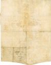
| Date: | 08 18 1821 |
|---|---|
| Description: | The reverse side of the Green Bay treaty, August 18, 1821. The treaty is signed by the chiefs of the six Indian nations for the possession of lands near th... |

| Date: | 08 27 1825 |
|---|---|
| Description: | Map is ink on paper. Map shows plat of the town of Munnomunne, the Fox River, farm lots, and an established highway. The map is signed by "J.D. Doty, Propr... |

| Date: | 1836 |
|---|---|
| Description: | This map of Navarino shows a development plat of the village situated opposite Fort Howard at mouth of the Fox River. The names of proprietors are listed a... |

| Date: | 1856 |
|---|---|
| Description: | This map shows a plat of town, local streets, and parts of East and Fox Rivers. |

| Date: | 1868 |
|---|---|
| Description: | This map shows land ownership by name, lots, roads, railroads, and part of the Fox River. The map includes an explanation and table of witnesses to the cor... |

| Date: | 1874 |
|---|---|
| Description: | This map shows streets, buildings, railroads, the Fox River, the East River, and part of Green Bay. |

| Date: | 1882 |
|---|---|
| Description: | Four women relax and have fun together, sitting on the grass, wearing hats and long dresses. Two of them hold a cigarette in their hand, the other two have... |

| Date: | 1862 |
|---|---|
| Description: | This map shows landownership on a military reserve, private claims, buildings (including Fort Howard and U.S. sawmill), swamps, public barns and fields, an... |

| Date: | 1895 |
|---|---|
| Description: | Interior view of the parlor and dining room of the Straubel home. A piano is in the parlor in the foreground, and a woman is standing next to the dining ro... |
If you didn't find the material you searched for, our Library Reference Staff can help.
Call our reference desk at 608-264-6535 or email us at: