Filter: Categories of Wisconsin Historical Images
Filter: Community of Hustisford
Filter: Year of 1900-1999
Filter: Categories of Wisconsin Historical Images
Filter: Community of Hustisford
Filter: Year of 1900-1999

| Date: | 1910 |
|---|---|
| Description: | Left half of a plat map of Hustisford in Dodge County. |

| Date: | 1910 |
|---|---|
| Description: | The right half of a plat map of Hustisford in Dodge County. |
| Date: | 04 03 1998 |
|---|---|
| Description: | "Our group visits Hustisford, WI and we dine at the Lake St. Hotel. Later we learn that the name was changed, about two months ago, and it is now called Mo... |

| Date: | 04 03 1998 |
|---|---|
| Description: | "Our waitress, Laurie Kuehl, sits down and jokes with us at the Mosey on Inn. Laurie informs us that her brother is the proprietor and her mother helps out... |

| Date: | 11 15 1957 |
|---|---|
| Description: | This map shows single family residence district, business district, and manufacturing district, as well as block and lot numbers, Hustis Homestead, gravel ... |
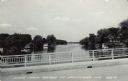
| Date: | 1961 |
|---|---|
| Description: | View of the Rock River from a bridge at Hustisford. The river is lined with boathouses. Caption reads: "Scene from Bridge at Hustisford, Wis." |
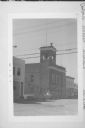
| Date: | 08 1974 |
|---|---|
| Description: | Exterior view of Hustisford City Hall at 210 South Lake Street. There is a siren on top of the building. |
If you didn't find the material you searched for, our Library Reference Staff can help.
Call our reference desk at 608-264-6535 or email us at: