 Filter: Categories of Wisconsin Historical Images
Filter: County of Burnett
Filter: Subject of land use
Filter: Categories of Wisconsin Historical Images
Filter: County of Burnett
Filter: Subject of land use
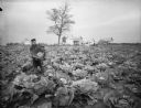
| Date: | 09 28 1895 |
|---|---|
| Description: | Five-acre cabbage field of Martin Anderson near Grantsburg, with several frame houses in the background. Mr. Anderson is holding a prize-winning head of ca... |

| Date: | 1930 |
|---|---|
| Description: | Saint Croix Ojibwa man, bare-chested, wearing a feather war bonnet. |

| Date: | 1921 |
|---|---|
| Description: | A man sits on top of a mound near Trade Lake. |

| Date: | 1921 |
|---|---|
| Description: | Three men and four children standing on top of a mound near Round Lake. |

| Date: | 1927 |
|---|---|
| Description: | Three men and two women sit on top of a mound near Trade Lake. |

| Date: | 1867 |
|---|---|
| Description: | This 1867 map shows the Chippewa River in northern Chippewa County, Wisconsin, from just north of Cornell to Jim Falls. Covering portions of the towns of A... |

| Date: | 1914 |
|---|---|
| Description: | Map shows school houses, creameries, post offices, saw mills, grist mills, churches, cemeteries, town halls, stores, roads, state roads, and railroads. "Co... |
If you didn't find the material you searched for, our Library Reference Staff can help.
Call our reference desk at 608-264-6535 or email us at: