Filter: Categories of Wisconsin Historical Images
Filter: County of Crawford
Filter: Subject of formations (geology)
Filter: Categories of Wisconsin Historical Images
Filter: County of Crawford
Filter: Subject of formations (geology)
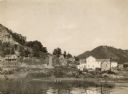
| Date: | 1905 |
|---|---|
| Description: | View looking toward old Diamond Jo Warehouse, before the bridge was built. Caption reads: "Mississippi River and Prairie du Chien, Wis., from Iowa Side". |
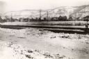
| Date: | 1918 |
|---|---|
| Description: | View of the Burlington Railroad tracks south of the city, near Campion College. Dwellings are across a field, and snow-covered bluffs are in the background... |
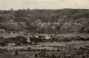
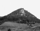
| Date: | 1925 |
|---|---|
| Description: | View from a distance of Campion College. Bluffs are in the background. |

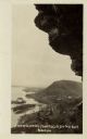
| Date: | |
|---|---|
| Description: | Elevated view of four people posing on a large outcropping of rocks in a wooded area. |
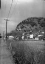
| Date: | 1936 |
|---|---|
| Description: | View along side of road across a field of a village on the Mississippi bluffs, with many houses and telephone lines visible. |

| Date: | |
|---|---|
| Description: | View across water towards two paddle-wheel boats steering logs into a neat, square formation. The boat in the foreground bears the name "Georgie S." Bluffs... |
| Date: | |
|---|---|
| Description: | View across double set of railroad tracks and field towards steep bluff with exposed rock. |
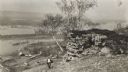
| Date: | 1915 |
|---|---|
| Description: | Elevated view of the Mississippi River from a bluff. There is a farm and other houses along the shoreline, and in the foreground a boy stands on the bluff ... |
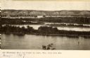
| Date: | 1920 |
|---|---|
| Description: | Black and white photographic postcard view of De Soto, taken from the cliff south of town, looking north along the Mississippi River. Caption reads: "A Vie... |

| Date: | 09 01 1856 |
|---|---|
| Description: | This map is pen-and-ink and shows farm lots, other lots of land sectioned by acres, bluffs, and a coulee. Also included are notations in pencil and blue in... |

| Date: | 1839 |
|---|---|
| Description: | This map shows the geological makeup of the valley in red, yellow, and green, the Mississippi River, and the location of Fort Crawford. The geology on the ... |

| Date: | 1950 |
|---|---|
| Description: | View of an automobile traveling north on Highway 35, near the Mississippi River. Railroad tracks run between the road and the river. In the background are ... |
If you didn't find the material you searched for, our Library Reference Staff can help.
Call our reference desk at 608-264-6535 or email us at: