 Filter: Categories of Wisconsin Historical Images
Filter: County of Crawford
Filter: Subject of railroads
Filter: Categories of Wisconsin Historical Images
Filter: County of Crawford
Filter: Subject of railroads
| Date: | |
|---|---|
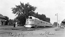
| Description: | The diesel-powered Zephyr passenger train of the Chicago, Burlington & Quincy Railroad on the tracks at the depot. The Zephyr was introduced at the Chicago... |
| Date: | |
|---|---|
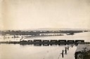
| Description: | Elevated view of the pile-pontoon railroad bridge across the Mississippi River at Prairie du Chien. The bridge was built and patented by John Lawler in 187... |
| Date: | 08 29 1930 |
|---|---|
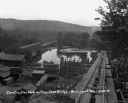
| Description: | View from top of new bridge of construction grounds at the bridge site. There are cars carrying building materials on the railroad tracks by the Bridgeport... |

| Date: | 1878 |
|---|---|
| Description: | This map of Crawford County, Wisconsin, shows the township and range grid, sections, towns, cities and villages, land ownership and acreages, roads, railro... |

| Date: | 1911 |
|---|---|
| Description: | Blue line print. Shows post offices, houses, schools, churches, roads, routes, rivers, and railroads. Includes explanation of symbols. "H.G.M. October 12,... |

| Date: | 1890 |
|---|---|
| Description: | This is a plat map of "Wauzeeka" drawn in pencil. The map shows numbered lots, labeled streets, the Kickapoo River, and railroads. The map reads: "Laid out... |

| Date: | 1859 |
|---|---|
| Description: | Steam-powered car designed to run on ice across the Mississippi River at Prairie du Chien. The LADY FRANKLIN made one successful trip across, but wa... |

| Date: | 1976 |
|---|---|
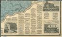
| Description: | This map includes an index of streets, government and historic buildings, hospitals, schools, places of recreation, churches, cemeteries, and other miscell... |

| Date: | 1856 |
|---|---|
| Description: | This map shows lot and block numbers, streets, a mill, the Milwaukee and Mississippi Railroad, the train depot, and the Kickapoo River. Included in the low... |

| Date: | 1856 |
|---|---|
| Description: | This map shows lot and block numbers, streets, depot building, and the Milwaukee & Mississippi Rail Road. |

| Date: | 1856 |
|---|---|
| Description: | This map is ink and color on paper and mounted on cloth. The map shows lot and block numbers, streets, a railroad, and the Kickapoo River. Some lots are c... |
| Date: | 1878 |
|---|---|
| Description: | The bottom right corner of a map of Crawford County. This portion of the map includes town directories and illustrations of the Court House in Prairie Du C... |
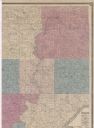
| Date: | 1878 |
|---|---|
| Description: | Portion of a map of Crawford County. |
If you didn't find the material you searched for, our Library Reference Staff can help.
Call our reference desk at 608-264-6535 or email us at:
