 Filter: Categories of Wisconsin Historical Images
Filter: County of Douglas
Filter: Categories of Wisconsin Historical Images
Filter: County of Douglas
| Date: | 02 1977 |
|---|---|
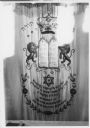
| Description: | Hebrew Brotherhood Synagogue torah. |
| Date: | 02 1977 |
|---|---|
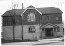
| Description: | Exterior view from street of the Hebrew Brotherhood Synagogue. |
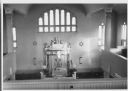
| Date: | 02 1977 |
|---|---|
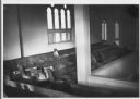
| Description: | A view of the women's balcony in the Hebrew Brotherhood Synagogue. |
| Date: | 02 1977 |
|---|---|
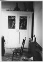
| Description: | A side room in the synagogue, with a bench and a chair in the foreground, and a cabinet with glass windows against the wall in the background. |
| Date: | 02 1977 |
|---|---|
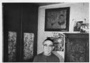
| Description: | Rabbi Alex Hyatt stands in front of framed photographs displayed on the wall. |
| Date: | 02 1977 |
|---|---|
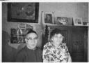
| Description: | Rabbi Alex Hyatt and his wife Bernice Hyatt. Framed portraits are on the wall behind them. |
| Date: | 02 1977 |
|---|---|
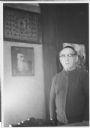
| Description: | Rabbi Alex Hyatt poses next to an framed portrait of a man with a white beard who is possibly also a rabbi. |
| Date: | 02 1977 |
|---|---|
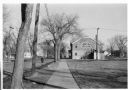
| Description: | View down sidewalk towards the exterior of the Hebrew Brotherhood Synagogue. |
| Date: | 02 1977 |
|---|---|
| Description: | Interior of the synagogue, including Stars of David on the walls. |
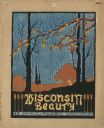
| Date: | 1910 |
|---|---|
| Description: | Watercolor design for a conservation poster made by a Wisconsin high school student as part of a competition. The poster has an image of trees in autumn. B... |
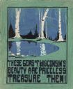
| Date: | 1910 |
|---|---|
| Description: | Watercolor design for a conservation poster made by a Wisconsin high school student as part of a competition. The poster has an image of birch trees on the... |
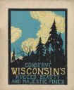
| Date: | 1910 |
|---|---|
| Description: | Watercolor design for a conservation poster made by a Wisconsin high school student as part of a competition. The poster has an image of pine trees in silh... |
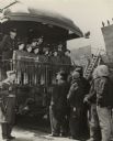
| Date: | 1943 |
|---|---|
| Description: | The five Dionne quintuplet girls, their sister and parents standing at the end of the observation car occupied by the Dionne party. They were in Superior t... |

| Date: | 1990 |
|---|---|
| Description: | This map shows the Minnesota Point, Wisconsin Point, Hog Island, Baker's Island, Connors Point, Blatnik Bridge, Superior Bay, Allouez Bay, the Nemadji Rive... |

| Date: | 1935 |
|---|---|
| Description: | This map shows rivers, lakes, communities, woods, fishing locations, and vacation destinations. The back of the map includes text about agricultural, sceni... |

| Date: | |
|---|---|
| Description: | View over parked cars towards the Superior Refinery, which did business as Murphy Oil Corporation at another time. The oil refinery was located at Stinson ... |

| Date: | |
|---|---|
| Description: | View across field towards the Superior Refinery, which operated under the name Murphy Oil Corporation at another time. |

| Date: | 1873 |
|---|---|
| Description: | This blueprint map shows water depths by soundings and isolines. To the top left is Duluth, Minnesota. To the bottom right is Superior City, Wisconsin. The... |

| Date: | 1966 |
|---|---|
| Description: | This blue line print shows existing and proposed streets, docks, company-owned land, railroads and railroad yards, parks, and municipal airport. |

| Date: | 1892 |
|---|---|
| Description: | A Sanborn map of St. Louis, which is six miles southwest of South Superior. |
If you didn't find the material you searched for, our Library Reference Staff can help.
Call our reference desk at 608-264-6535 or email us at: