Filter: Categories of Wisconsin Historical Images
Filter: County of Juneau
Filter: Subject of persons
Filter: Type of Photograph
Filter: Year of 1900-1999
Filter: Categories of Wisconsin Historical Images
Filter: County of Juneau
Filter: Subject of persons
Filter: Type of Photograph
Filter: Year of 1900-1999
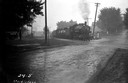
| Date: | 09 1936 |
|---|---|
| Description: | Chicago & Northwestern Railroad train crossing the Elroy-New Lisbon Road (Highway 80). |
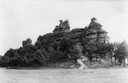
| Date: | 1937 |
|---|---|
| Description: | Castle Rock. Castle Rock is an example of a monadnock or inselberg, a geological formation common in northern and central Wisconsin. |
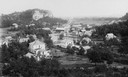
| Date: | 1910 |
|---|---|
| Description: | Elevated view of Camp Williams Town, with many houses. In the background are bluffs. |
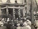
| Date: | 10 04 1936 |
|---|---|
| Description: | View over crowd towards Senator Robert M. La Follette, Jr., speaking to a Progressive Party rally at Mauston, Wisconsin. Bob, Jr., became senator after the... |
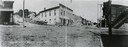
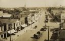
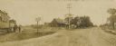
| Date: | 1907 |
|---|---|
| Description: | Panoramic view looking down Main Street, with horses and carriages parked outside the storefronts on the street. |
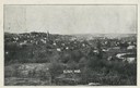
| Date: | 1900 |
|---|---|
| Description: | View from hill of downtown Elroy, with a church steeple and buildings. |
| Date: | 08 03 1973 |
|---|---|
| Description: | View of an Elroy alley from Cedar Street. The deteriorating garage in the foreground is of an unusual design. |

| Date: | 11 1957 |
|---|---|
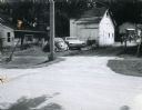
| Description: | Photograph taken by the State Highway Department to show the condition of curbs and gutters along STH 12 in Mauston, also documenting the original brick su... |
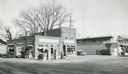
| Date: | 1957 |
|---|---|
| Description: | Skelly service station, restaurant, and motel located along STH 12 in Mauston, Wisconsin. |
| Date: | 11 11 1918 |
|---|---|
| Description: | Armistice Day celebration (mock funeral of Kaiser Wilhelm II). Soldier identified is William Carlson, who was disabled by the chemical agent mustard gas an... |
| Date: | 1940 |
|---|---|
| Description: | The Mesas and Buttes historical marker in Mill Bluff State Park. The marker reads: "Mesas and Buttes. These so-called mounds with flat tops and cliffed sid... |
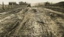
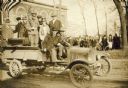
| Date: | 1926 |
|---|---|
| Description: | Car on a dirt highway west of Hustler. The highway is U.S. 12 and 16. |
| Date: | 1920 |
|---|---|
| Description: | Elevated view of town. There is an unusual automobile parking pattern in the center of State Street. There is a sign for "Billiards" on a building in the r... |
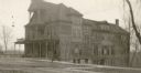
| Date: | 1919 |
|---|---|
| Description: | View across street towards the front and right side of the Juneau Hotel. |
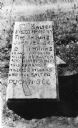
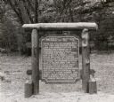
| Date: | 1925 |
|---|---|
| Description: | Salter marker between Necedah and New Lisbon, marks spot where some Indians killed a Mrs. George Salter on June 13, 1863. Mr. Salter had a log tavern here ... |
| Date: | 1940 |
|---|---|
| Description: | Salter marker between Necedah and New Lisbon, marks spot where some Indians killed a Mrs. George Salter on June 13, 1863. Mr. salter had a log tavern here ... |
| Date: | 1904 |
|---|---|
| Description: | View of crossroads where the street meets the railroad tracks. Adults and children are standing to the left next to a train. |
If you didn't find the material you searched for, our Library Reference Staff can help.
Call our reference desk at 608-264-6535 or email us at: