 Filter: Categories of Wisconsin Historical Images
Filter: County of Marathon
Filter: Subject of cities and towns
Filter: Categories of Wisconsin Historical Images
Filter: County of Marathon
Filter: Subject of cities and towns

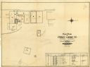
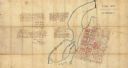
| Date: | 1965 |
|---|---|
| Description: | Map shows original plat, plat additions, and lot measurements for Rothschild, Wisconsin. Lake Wausau and the Wisconsin River are labelled. Map reads: "Comp... |
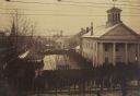
| Date: | 12 18 1890 |
|---|---|
| Description: | Elevated view looking down at homestead applicants waiting in line for 2-3 days in winter cold before a window in the Marathon County Court House, Dec. 18-... |
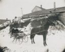
| Date: | 1906 |
|---|---|
| Description: | Winter scene with a man and woman driving in a horse-drawn "cutter" in the snow. They have a fur blanket over their laps. Behind them is a building, perhap... |

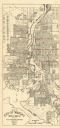
| Date: | 1932 |
|---|---|
| Description: | This map of Wausau shows lots and landownership, buildings, roads, railroads, parks, city wards, and the Wisconsin River. The map features an inset map sho... |
| Date: | 1955 |
|---|---|
| Description: | This map of Wausau distributed by the Wausau Chamber of Commerce was originally published in July of 1940 and shows the Wisconsin River. The map includes a... |
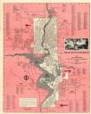
| Date: | 1954 |
|---|---|
| Description: | This map of Wausau is pink, red, gray, and white. The map includes indexes of streets, industries, and community buildings and features a photograph of the... |
| Date: | 1928 |
|---|---|
| Description: | This plat map of Wausau is oriented with north to the right and is dated "April, 1928." The map features a building description chart with an index and inc... |
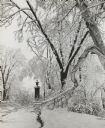
| Date: | 1963 |
|---|---|
| Description: | Winter scene with snow-covered trees after a storm in Gooding Park. |
| Date: | 1892 |
|---|---|
| Description: | This map shows lot and block numbers and dimensions, some landownership, wards, railroads, streets, and mills. The map includes 5 plat additions that have ... |
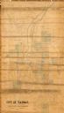
| Date: | 1965 |
|---|---|
| Description: | This map shows lot and block numbers and dimensions, additions, streets, and railroads. |

| Date: | 1912 |
|---|---|
| Description: | Aftermath of a flood. Debris of railroad ties, tracks, and cars are scattered beneath a bridge. |

| Date: | 1916 |
|---|---|
| Description: | Water of Big Bull Falls or the Wisconsin River rapidly flows underneath two railroad bridges. Pedestrians cross the bridges while peering over at the over... |

| Date: | 1913 |
|---|---|
| Description: | Dr. Joseph Smith's home at 118 E Scott, which is a corner lot close to the tree-lined road. Rocking chairs sit on the front porch. |

| Date: | 1968 |
|---|---|
| Description: | Joan and Craig Obey stand together in their driveway as Craig waves. The Obey's first house, at 515 North Ninth Avenue, and trees can be seen behind them. |

| Date: | 1982 |
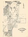
|---|---|
| Description: | Color map. "Topography by photogrammetric methods from aerial photographs taken 1963. Revised from aerial photographs taken 1978. Field checked 1979. Map e... |
| Date: | 1857 |
|---|---|
| Description: | This manuscript map is ink and watercolor on tracing cloth and shows bridges, lots, and streets. Some of the lots are in pink ink. The left of the map incl... |

| Date: | 1915 |
|---|---|
| Description: | This map is mounted on cloth and shows lots and landownership, selected buildings, roads, railroads, parks, cemeteries, city wards, and includes advertisem... |

| Date: | 1987 |
|---|---|
| Description: | This pictorial map shows roads, bridges, local businesses with phone numbers, and public buildings. Relief is shown pictorially. Also included is a calen... |

| Date: | 1899 |
|---|---|
| Description: | This map is ink on tracing cloth and shows lot and block numbers and dimensions, streets, the high school park, and survey monuments. The map is oriented ... |
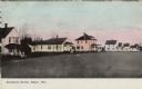
| Date: | 1908 |
|---|---|
| Description: | Colorized view of a row of wood frame houses. Caption reads: "Residence Street, Edgar, Wis." |
If you didn't find the material you searched for, our Library Reference Staff can help.
Call our reference desk at 608-264-6535 or email us at: