 Filter: Categories of Wisconsin Historical Images
Filter: County of Sheboygan
Filter: Subject of transportation
Filter: Categories of Wisconsin Historical Images
Filter: County of Sheboygan
Filter: Subject of transportation
| Date: | 1858 |
|---|---|
| Description: | Ambrotype of the Wade House, a carriage inn located in Greenbush, also showing a section of the original plank road in the foreground. |
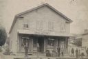
| Date: | 1888 |
|---|---|
| Description: | Exterior view of Charles Pfeifer's Drugstore, founded in 1858. From left to right are Charles Pfeifer, Fred Pfeifer, Mrs. Adam Heeb, Fulda Pfeifer, Mrs. Ch... |
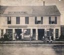
| Date: | 1864 |
|---|---|
| Description: | Street scene with customers in front of the M.P. Roberts Drugstore and C. Baack Flour and Feed Store. |
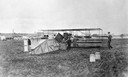
| Date: | 1912 |
|---|---|
| Description: | Lincoln Beachey's Curtiss Pusher and the crates in which the airplane was transported by rail to the Sheboygan fairgrounds. At the time, Lincoln Beachey wa... |
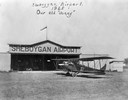
| Date: | 1925 |
|---|---|
| Description: | The first Sheboygan Airport operated by Anton Brotz, Sr. Parked in front of the hangar is a Curtiss "Jenny," as the World War I-era Curtiss JN models were ... |
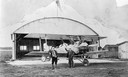
| Date: | 1925 |
|---|---|
| Description: | The second Sheboygan airport was built by owner Anton Brotz, Sr. after a fire destroyed his first hangar. Brotz is photographed here with his son, Anton, J... |
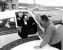
| Date: | |
|---|---|
| Description: | The real flying nun, Sister Mary Aquinas Kinskey, arriving at Sheboygan County Airport with two Franciscan sisters in a Cherokee C airplane. Sister Mary Aq... |
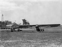
| Date: | |
|---|---|
| Description: | The airport at Kohler. On the ground (right) is "The Village of Kohler," the Mahoney-Ryan-Brougham owned by Walter Kohler, Sr., and Carl Kohler's Aeronica ... |

| Date: | 1885 |
|---|---|
| Description: | Bird's-eye view of Sheboygan, with inset of J.J. Volrath Manufacturing Company. |

| Date: | 1914 |
|---|---|
| Description: | This map shows Sheboygan in 1914. The top of the map has the date of "NOV 17 1916" stamped in red ink. The map shows numbered plots and labeled streets, an... |
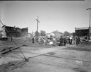
| Date: | 08 30 1931 |
|---|---|
| Description: | Ruins from fire. There are railroad tracks in the foreground, and people standing and looking at the damage. |
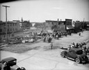
| Date: | 08 30 1931 |
|---|---|
| Description: | Elevated view of crowds gathering to survey the smoke and ash left after a fire demolished buildings. |
| Date: | 05 18 1948 |
|---|---|
| Description: | Elevated view of wreck of a Chicago, Milwaukee and St. Paul Railroad freight train. The derailment is so severe that the train station has been knocked off... |
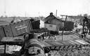
| Date: | 05 05 1905 |
|---|---|
| Description: | Observing the flood damage to railroad tracks in the business section of town. |
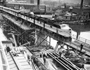
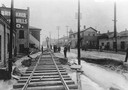
| Date: | 05 03 1948 |
|---|---|
| Description: | Elevated view of a Chicago and Northwestern passenger train, which is the first across a new bridge in Sheboygan. There is a group of people standing near ... |
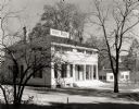
| Date: | 1953 |
|---|---|
| Description: | View of the Butternut House in the Kohler Foundation restoration project. The service building at the right in the background is operated by the Conservati... |
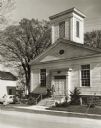
| Date: | 1950 |
|---|---|
| Description: | View of the First Methodist Church, with two women standing on the church steps, and another woman standing on the sidewalk. The church was built in 1854 b... |
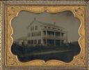
| Date: | 1920 |
|---|---|
| Description: | Front view of the Wade House. The Wade House, one of the earliest stagecoach inns in Wisconsin, was built between 1847 and 1851 by Sylvanus Wade. It became... |
If you didn't find the material you searched for, our Library Reference Staff can help.
Call our reference desk at 608-264-6535 or email us at:

