Filter: Categories of Wisconsin Historical Images
Filter: FORMAT_DIMENSIONS of ? x ?
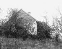
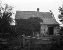
Filter: Community of Hustisford
Filter: Categories of Wisconsin Historical Images
Filter: FORMAT_DIMENSIONS of ? x ?
Filter: Community of Hustisford

| Date: | 1910 |
|---|---|
| Description: | Left half of a plat map of Hustisford in Dodge County. |

| Date: | 1910 |
|---|---|
| Description: | The right half of a plat map of Hustisford in Dodge County. |
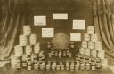
| Date: | |
|---|---|
| Description: | Honey display for Honey Week (November 19-25). W.E. Reim, C.E. Trout. |

| Date: | 11 15 1957 |
|---|---|
| Description: | This map shows single family residence district, business district, and manufacturing district, as well as block and lot numbers, Hustis Homestead, gravel ... |
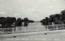
| Date: | 1961 |
|---|---|
| Description: | View of the Rock River from a bridge at Hustisford. The river is lined with boathouses. Caption reads: "Scene from Bridge at Hustisford, Wis." |
If you didn't find the material you searched for, our Library Reference Staff can help.
Call our reference desk at 608-264-6535 or email us at: