 Filter: Categories of Wisconsin Historical Images
Filter: FORMAT_DIMENSIONS of 17 x 14 inches
Filter: Type of Map or Atlas
Filter: Categories of Wisconsin Historical Images
Filter: FORMAT_DIMENSIONS of 17 x 14 inches
Filter: Type of Map or Atlas
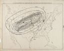
| Date: | 1871 |
|---|---|
| Description: | Weather map depicting the great cyclonic storm that prevailed the day of the Peshtigo and Chicago fires. |
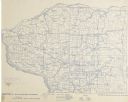
| Date: | 1896 |
|---|---|
| Description: | Section 4 of 12, this bicycle road map features Wisconsin bicycle routes in the counties of Iowa, Grant, and La Fayette. |
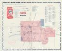
| Date: | 1963 |
|---|---|
| Description: | A map with handwritten notes and locations for Freedom Fighters participating in the Canton Boycott, for orientation during picketing. It is not a map show... |

| Date: | 1899 |
|---|---|
| Description: | A plat map of Burke, Cottage Grove, McFarland, Waunakee, Quarry Town, Klevenville, and Vilas. |
If you didn't find the material you searched for, our Library Reference Staff can help.
Call our reference desk at 608-264-6535 or email us at:
