 Filter: Categories of Wisconsin Historical Images
Filter: FORMAT_DIMENSIONS of 6 x 4.5 inches
Filter: Subject of transportation
Filter: Categories of Wisconsin Historical Images
Filter: FORMAT_DIMENSIONS of 6 x 4.5 inches
Filter: Subject of transportation

| Date: | 1835 |
|---|---|
| Description: | Little Lake Butte Des Morts just north of Lake Winnebago where Governor Lewis Cass of Michigan, and Thomas McKenney, head of the Bureau of Indian Affairs (... |
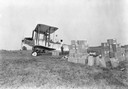
| Date: | 1925 |
|---|---|
| Description: | Loading an airplane with calcium arsenate in order to spray for the hemlock looper pest in Peninsula State Park. This is believed to be the first such use ... |

| Date: | 1956 |
|---|---|
| Description: | Exterior view of the Kierig-Babbitt building, built in 1880. |

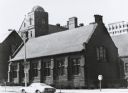
| Date: | |
|---|---|
| Description: | View of the church. A dusting of snow is on the church lawn. The church has a tall spire, and stained-glass windows with gothic arches. First Presbyterian ... |
| Date: | 04 09 1934 |
|---|---|
| Description: | View from street towards the Fort Howard Hospital. |
| Date: | |
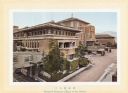
|---|---|
| Description: | Illustration labelled "Banquet Entrance (Rear of the Hotel) from brochure about the Imperial Hotel (see ID#32422, 32451-2, and 32454) |

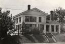
| Date: | 1925 |
|---|---|
| Description: | View across road towards Governor Nelson Dewey's house. |

| Date: | 1912 |
|---|---|
| Description: | View from road of the Briggs Hotel, which burned down in 1913. |

| Date: | 1840 |
|---|---|
| Description: | Fort Crawford (the second site, with buildings of 1829-?), on the east bank of the Mississippi River, about 2 miles above the mouth of the Wisconsin River. |

| Date: | 1936 |
|---|---|
| Description: | Elevated view over the long roof of the Diamond Jo warehouse. The Mississippi River is on the left, with hills in the background. |
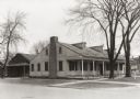
| Date: | 1935 |
|---|---|
| Description: | View of the Blake House (north elevation, front). The house was razed prior to 1952. |
| Date: | 1935 |
|---|---|
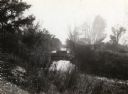
| Description: | Elevated view of the Indian Agency House near the site of Fort Winnebago. View of Portage Canal in foreground. The canal was dug in 1849 as part of the Fox... |
| Date: | 1935 |
|---|---|
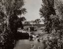
| Description: | A view of the Portage Canal. In the immediate foreground is the Fox River, then the lower locks and the canal itself. The Indian Agency House may be seen t... |
| Date: | 1917 |
|---|---|
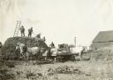
| Description: | A group of farmers feeds grain into a thresher with a horse-drawn wagon nearby. |

| Date: | 1900 |
|---|---|
| Description: | Exterior of Plow (Plough) Inn, located at 3402 Monroe Street. An early view of the tavern which derived its name from the Fuller & Johnson plows for sale o... |

| Date: | |
|---|---|
| Description: | An exterior view of the first Tenney Building, located at South Pinckney and East Main Streets. |
| Date: | 1925 |
|---|---|
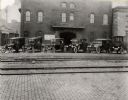
| Description: | Taxi cabs and their drivers are awaiting customers near the Chicago, Milwaukee, St. Paul and Pacific Railroad depot on East Wilson Street. In the center of... |
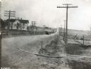
| Date: | 1917 |
|---|---|
| Description: | A caravan of trucks en route from International Harvester's Akron Works factory in Ohio to Chicago is traveling down a rural road lined with telephone pole... |
| Date: | 1972 |
|---|---|
| Description: | Green Hall from the northeast. North end of Johnson Hall is at left foreground. Observatory tower and roof details of Merrill Hall in center background. |
If you didn't find the material you searched for, our Library Reference Staff can help.
Call our reference desk at 608-264-6535 or email us at:
