 Filter: Categories of Wisconsin Historical Images
Filter: FORMAT_DIMENSIONS of unknown
Filter: Subject of transportation
Filter: Year of 1900-1999
Filter: Categories of Wisconsin Historical Images
Filter: FORMAT_DIMENSIONS of unknown
Filter: Subject of transportation
Filter: Year of 1900-1999

| Date: | 1901 |
|---|---|
| Description: | A Sanborn map of Tomahawk featuring the Bay Mill Company's lumber yard. |

| Date: | 04 1901 |
|---|---|
| Description: | A Sanborn map of Watertown, including an index and a key. |

| Date: | 09 28 1914 |
|---|---|
| Description: | Town of Saales. Bombarded by the French on September 28. |

| Date: | 1999 |
|---|---|
| Description: | Exterior view of Waupun City Hall, 201 E. Main Street, built in 1928. |

| Date: | 01 1980 |
|---|---|
| Description: | Exterior view of the Nathan Shapiro House at 3059 South Kinnickinnic Avenue. |
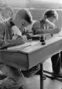
| Date: | 05 29 1963 |
|---|---|
| Description: | Caption with photograph: "Quill pens with a modern touch are being used by Richard Rice, 12, (left front) and Russell Guth, 10; and behind them is Daniel N... |

| Date: | 1908 |
|---|---|
| Description: | A Sanborn fire map of Brodhead. Includes an inset at top right showing distances from P.O. |

| Date: | 1908 |
|---|---|
| Description: | A Sanborn map of the isthmus, which includes the map key. |

| Date: | 1908 |
|---|---|
| Description: | A Sanborn map including a portion of the East Johnson Street and East Gorham Street neighborhood. |
If you didn't find the material you searched for, our Library Reference Staff can help.
Call our reference desk at 608-264-6535 or email us at:


