 Filter: Categories of Wisconsin Historical Images
Filter: FORMAT_DIMENSIONS of unknown
Filter: Subject of transportation
Filter: Categories of Wisconsin Historical Images
Filter: FORMAT_DIMENSIONS of unknown
Filter: Subject of transportation

| Date: | 1873 |
|---|---|
| Description: | A hand-colored map of Minnesota, Wisconsin, and Michigan shows the counties, cities, villages, rivers, lakes, railroads, and steamboat routes in these stat... |

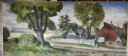
| Date: | 1885 |
|---|---|
| Description: | Main Street in Bayfield in 1870 with four cows standing in the street. |

| Date: | |
|---|---|
| Description: | Three men are posing in a stand of pines. On the left two men are standing and holding axes, and on the right is a man posing sitting in a wagon loaded wit... |

| Date: | 1948 |
|---|---|
| Description: | Prior to the 1948 State Fair, artist Robert Hodgell traveled Wisconsin to study its many landscapes. He then produced a series of study sketches outlining ... |
| Date: | 1948 |
|---|---|
| Description: | Prior to the 1948 State Fair, artist Robert Hodgell traveled Wisconsin to study its many landscapes. He then produced a series of study sketches outlining ... |

| Date: | 1948 |
|---|---|
| Description: | Prior to the 1948 State Fair, artist Robert Hodgell traveled Wisconsin to study its many landscapes. He then produced a series of study sketches outlining ... |

| Date: | 1948 |
|---|---|
| Description: | Prior to the 1948 State Fair, artist Robert Hodgell traveled Wisconsin to study its many landscapes. He then produced a series of study sketches outlining ... |

| Date: | 1948 |
|---|---|
| Description: | Prior to the 1948 State Fair, artist Robert Hodgell traveled Wisconsin to study its many landscapes. He then produced a series of study sketches outlining ... |

| Date: | 11 14 1942 |
|---|---|
| Description: | This pictorial map illustrates Potawatomi Indian legends from the region of Lower Phantom Lake, labeled Howitt Lake on the map, Phantom Lake, and Mukwonag... |
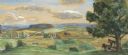
| Date: | 1948 |
|---|---|
| Description: | A painting of a dairy farm, which was part of the State Fair Centennial mural. |
| Date: | 1947 |
|---|---|
| Description: | Abandoned enlisted men's barracks at Truax Field. |

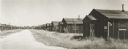
| Date: | 1966 |
|---|---|
| Description: | View from behind of a man standing on railroad tracks surveying a row of dilapidated shanties. Used on the cover of brochure with the title, 'Mississippi 1... |

| Date: | 1840 |
|---|---|
| Description: | This map shows local streets, numbered lots, and part of Blue Mounds Branch. The map reads: "NE 1/4 NW 1/4 Sect. 16 - T5 - R5E." under the title and is dat... |
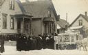
| Date: | |
|---|---|
| Description: | An elaborate funeral hearse is pulled up to a house with the back doors open, waiting to be loaded with the casket. There are many men and women bundled up... |
If you didn't find the material you searched for, our Library Reference Staff can help.
Call our reference desk at 608-264-6535 or email us at:


