 Filter: Categories of Wisconsin Historical Images
Filter: FORMAT_TYPE of photographic print, b
Filter: Subject of botany
Filter: Subject of church buildings
Filter: Categories of Wisconsin Historical Images
Filter: FORMAT_TYPE of photographic print, b
Filter: Subject of botany
Filter: Subject of church buildings
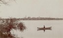
| Date: | 1894 |
|---|---|
| Description: | Man in a rowboat on Lake Monona with a view of the city in the background. |
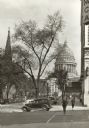
| Date: | 1939 |
|---|---|
| Description: | View down sidewalk along West Washington Avenue, looking toward the Capitol. A man is crossing the street and there is a car at the corner that has the wor... |
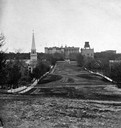
| Date: | 1868 |
|---|---|
| Description: | View from unpaved Wisconsin Avenue looking east toward the third Wisconsin State Capitol sometime prior to the completion of the dome (1869). The portion o... |
| Date: | 1920 |
|---|---|
| Description: | View from the water of the Mission, dock, Mission cottages, and Congregational Church on Madeline Island. |
| Date: | 1913 |
|---|---|
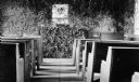
| Description: | Interior of Congregational Church located on the Mission grounds at La Pointe. Shows the walls covered with vegetation, and pews and an altar. |
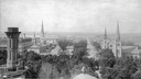
| Date: | 1890 |
|---|---|
| Description: | Site of the Battle to Antietam, The Dunker Church. A group of men stand among trees on the left. Horse-drawn carriages are under trees on the right. |

| Date: | 1908 |
|---|---|
| Description: | A panoramic aerial view of the Isthmus taken from a kite. Lake Mendota is to the right in the background with Picnic Point jutting into the lake. The photo... |
| Date: | 1940 |
|---|---|
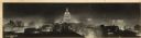
| Description: | Panorama view, elevated, of the Wisconsin State Capitol at night from the roof of a building on Monona Avenue. The First National Bank and the Belmont Hote... |
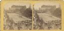
| Date: | 1877 |
|---|---|
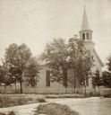
| Description: | Stereograph view of the exterior of Assembly Presbyterian Church, surrounded by trees. |
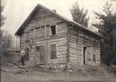
| Date: | 1870 |
|---|---|
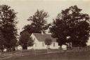
| Description: | The first Norwegian Lutheran church in Crawford County; a log structure with man standing in front. |
| Date: | |
|---|---|
| Description: | Elevated view from the Wisconsin State Capitol dome toward West Washington Avenue. The Park Hotel is on the left. The four church steeples that can be iden... |
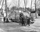
| Date: | 03 28 1938 |
|---|---|
| Description: | Hadley-Luzerne Central School students with books and lunch pails getting off of an International D-40 school bus. The bus featured a 215-inch wheelbase an... |

| Date: | 1861 |
|---|---|
| Description: | View of Madison from Main Hall, now Bascom Hall, on the University of Wisconsin-Madison campus looking up State Street toward the second Wisconsin State Ca... |
| Date: | 1861 |
|---|---|
| Description: | View of Madison from Main Hall, now Bascom Hall, on the University of Wisconsin-Madison campus. North Hall is in the foreground with several residences and... |
| Date: | 1905 |
|---|---|
| Description: | Construction crew building a double streetcar track around the Capitol Square on North Pinckney Street. The oversized awnings were common around the Square... |
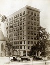
| Date: | 1915 |
|---|---|
| Description: | Exterior view of the neoclassical Gay Building, named after Madison developer Leonard W. Gay, at 16 N Carroll Street, one of the first high-rise buildings ... |
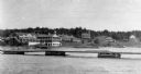
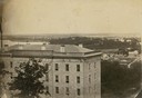
| Date: | 1906 |
|---|---|
| Description: | View of Madison from Lake Monona with the Wisconsin State Capitol building in the background. This view of Brittingham Park shows a part of the park shortl... |

| Date: | 1897 |
|---|---|
| Description: | A view from the capitol looking west up State Street toward the University of Wisconsin-Madison with the Holy Redeemer Church, Holy Redeemer School, Red Gy... |
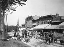
| Date: | 07 04 1876 |
|---|---|
| Description: | Stereograph of view of procession, military company and citizens at Great Centennial Day at the Capitol Square. Scene at Main and Carroll Streets showing t... |

| Date: | 1867 |
|---|---|
| Description: | Bird's-eye map of Green Bay and Fort Howard, Brown Co., depicts street names and street layouts, houses, trees, and the East River. A reference key at the ... |
If you didn't find the material you searched for, our Library Reference Staff can help.
Call our reference desk at 608-264-6535 or email us at: