 Filter: Categories of Wisconsin Historical Images
Filter: FORMAT_TYPE of prints, photomechanical
Filter: Community of Madison
Filter: Subject of roads
Filter: Categories of Wisconsin Historical Images
Filter: FORMAT_TYPE of prints, photomechanical
Filter: Community of Madison
Filter: Subject of roads
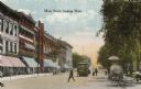
| Date: | 1900 |
|---|---|
| Description: | View down Main Street on the Capitol Square. Caption reads: "Main Street, looking West." |

| Date: | 1910 |
|---|---|
| Description: | Map of Dane County rural delivery in Madison and the town of Westport. |

| Date: | 1867 |
|---|---|
| Description: | Bird's-eye map of Madison with insets of the University, Rasdall House, Vilas House, and the Wisconsin State Capitol. View includes cattail marsh, smokesta... |

| Date: | 1885 |
|---|---|
| Description: | Bird's-eye map of Madison, State Capital of Wisconsin, County Seat of Dane County, with inset of the Wisconsin State Capitol. |

| Date: | 1949 |
|---|---|
| Description: | Color bird's-eye map of the University of Wisconsin-Madison as it was midcentury, with two co-eds, several photographs of campus landmarks around edges, an... |

| Date: | 1906 |
|---|---|
| Description: | View of Lake Mendota Drive at the foot of Stevens Hill. |
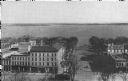
| Date: | 1914 |
|---|---|
| Description: | Monona Avenue with Lake Monona in the background. (Martin Luther King, Jr. Boulevard as of January 19, 1987). View from the dome of the Wisconsin State Cap... |

| Date: | 1904 |
|---|---|
| Description: | This map shows a plat of the east part of the city, numbered blocks and lots, some landownership, local streets, roads, railroads, wards by number, parks, ... |

| Date: | 1856 |
|---|---|
| Description: | Isthmus of Madison, including Lake Mendota, or Great Lake, and Lake Menona [sic]. |

| Date: | 1904 |
|---|---|
| Description: | This map shows a plat of the west part of the city, numbered blocks and lots, some landownership, local streets, roads, railroads, wards by number, parks, ... |

| Date: | 1855 |
|---|---|
| Description: | Map of the city of Madison, Dane County, published by George Harrison, surveyed and drawn by P. McCabe, and engraved by J.H. Colton & Co., New York. In add... |
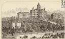
| Date: | 1874 |
|---|---|
| Description: | State University (University of Wisconsin), Madison. |

| Date: | 1907 |
|---|---|
| Description: | The Madison General Hospital, 925 Mound Street, looking west from Park Street. Caption reads: "City Hospital, Madison, Wisconsin." |

| Date: | 1906 |
|---|---|
| Description: | View across the grounds towards the Mendota State Hospital (Mendota Mental Health Institute). Caption reads: "Mendota Hospital for Insane, Madison, Wis." |

| Date: | 1910 |
|---|---|
| Description: | The Park Hotel, 22 South Carroll Street, on the Capitol Square with pedestrians, automobiles and a streetcar. Caption reads: "New Prk Hotel, Madison, Wis." |
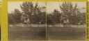
| Date: | 1868 |
|---|---|
| Description: | Stereograph of the Rublee house, among trees. The residence of Horace Rublee, formerly owned by J.A Ellis, on the east corner of Wisconsin Avenue and Gilma... |
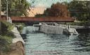
| Date: | 1910 |
|---|---|
| Description: | View of the Sherman Bridge and Lock and surrounding area on the Yahara River. Caption reads: "Sherman Avenue Bridge and Locks, Yahara River, Madison, Wis." |

| Date: | 1876 |
|---|---|
| Description: | Originally printed in the Centennial Records of the Women of Wisconsin on page 37. The elevated view illustrates the large houses and the surrounding bustl... |
If you didn't find the material you searched for, our Library Reference Staff can help.
Call our reference desk at 608-264-6535 or email us at:

