 Filter: Categories of Wisconsin Historical Images
Filter: FORMAT_TYPE of prints, photomechanical
Filter: County of Walworth
Filter: Community of Delavan
Filter: Categories of Wisconsin Historical Images
Filter: FORMAT_TYPE of prints, photomechanical
Filter: County of Walworth
Filter: Community of Delavan

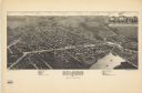
| Date: | 1884 |
|---|---|
| Description: | Bird's-eye map of Delavan with inset of the State Institute for Deaf and Dumb. |
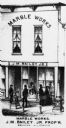
| Date: | 1873 |
|---|---|
| Description: | View of the J.M. Bailey Jr. Marble Works storefront. From the "Combination Atlas-Map of Walworth Co." Chicago. |
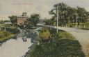
| Date: | 1910 |
|---|---|
| Description: | Distant view of the mill, with a stream leading to it, and a road paralleling the stream on the right. Caption reads: "The Old Mill, Delavan, Wis." |
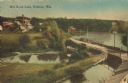
| Date: | 1905 |
|---|---|
| Description: | Elevated view of a pond, a stream, and a lake, with a road dividing the pond and stream from the lake. Industrial buildings and a smokestack are in the bac... |
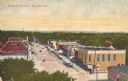
| Date: | |
|---|---|
| Description: | Elevated view of a broad downtown street. Caption reads: "Walworth Avenue, Delavan, Wis." |
| Date: | |
|---|---|
| Description: | Exterior of the property of the Wisconsin Institute for the Education of the Deaf and Dumb, with circle drive and people walking the grounds. |

| Date: | |
|---|---|
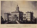
| Description: | Engraving of Wisconsin Institute for Deaf and Dumb. A man in a horse-drawn carriage and another rider on horseback travel along the street in the foregroun... |

| Date: | 1908 |
|---|---|
| Description: | Angled view of the left side of a residential street lined with trees, probably taken in early spring. The home of A.H. Allyn is on the left. A covered fou... |

| Date: | |
|---|---|
| Description: | Letterhead of the Wisconsin School for the Deaf in Delavan, Wisconsin, with a background image of an elevated view of the school? and surrounding grounds p... |
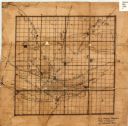
| Date: | 1840 |
|---|---|
| Description: | This 19th century manuscript map shows the roads and proposed routes, villages, and lakes and streams in Walworth County, Wisconsin. |

| Date: | 1966 |
|---|---|
| Description: | This 1966 map shows topography, roads, highways, golf courses, government buildings, and businesses around Delavan Lake in Walworth County, Wisconsin. Incl... |
| Date: | 1884 |
|---|---|
| Description: | This map is a Birdseye view of Delavan, Wisconsin. At the bottom of the map are points of interest that correspond to numbers on the map. Many of the stree... |

| Date: | 1966 |
|---|---|
| Description: | The map shows streets, wells, school land, parks, cemeteries, railroads, and the Delbrook Golf Course. The bottom of the map reads: "January 11, 1962 May 2... |
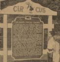
| Date: | 08 09 1963 |
|---|---|
| Description: | Gordon Yadon, a member of the Mabie Brothers circus tent, and Mary Lou Lawrence, aerialist and trapeze artist, reading the historical marker documenting De... |

| Date: | 1907 |
|---|---|
| Description: | Photographic collage of ten views of Delavan, including churches, lakes, and street scenes. Caption reads: "Views of Delavan, Wis." |
| Date: | |
|---|---|
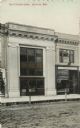
| Description: | Photographic view from unpaved street of the facade of Citizens' Bank. A confectionery and a dentist's office are next door on the right. Caption reads: "T... |
| Date: | |
|---|---|
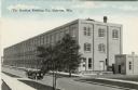
| Description: | Colored postcard of an illustration of a three-story industrial building on the other side of the street. There is an automobile driving by. Caption reads:... |
| Date: | |
|---|---|
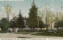
| Description: | Hand-colored view of the drive and front gate of the Wisconsin School for the Deaf. The main building is obscured by trees. Caption reads: "Wisconsin Schoo... |
| Date: | |
|---|---|
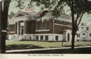
| Description: | Hand-colored view from street of the public library building on Fourth Street. Caption reads: "The Aram Public Library, Delavan, Wis." |
| Date: | |
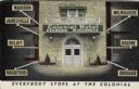
|---|---|
| Description: | The facade of the Colonial Hotel, with signs and markers to show how the hotels location relates to area communities. Caption reads: "Everybody Stops at th... |
If you didn't find the material you searched for, our Library Reference Staff can help.
Call our reference desk at 608-264-6535 or email us at: