 Filter: Categories of Wisconsin Historical Images
Filter: FORMAT_TYPE of prints, photomechanical
Filter: Subject of battles
Filter: Subject of battlefields
Filter: Categories of Wisconsin Historical Images
Filter: FORMAT_TYPE of prints, photomechanical
Filter: Subject of battles
Filter: Subject of battlefields

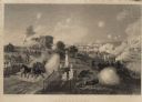
| Date: | 08 1862 |
|---|---|
| Description: | Color lithograph of Union lines in the midst of battle. |
| Date: | |
|---|---|
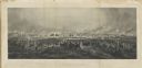
| Description: | Engraving excerpted from John S.C. Abbott's History of the Civil War in America. |
| Date: | |
|---|---|
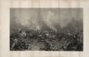
| Description: | An engraving after the painting by James Walker of the Battle of Gettysburg. |
| Date: | 1863 |
|---|---|
| Description: | An engraving of the Battle of Gettysburg, after the painting by P.F. Rothermel. |

| Date: | |
|---|---|
| Description: | Color postcard of a section of the cyclorama painting "Battle of Atlanta" executed by painters under Wilhem Wehner in the 1880s. This scene shows the fight... |

| Date: | 1864 |
|---|---|
| Description: | (U.S. 39th Cong. 1stt Sess. Report of Chief engineer) The legend in the upper left corner contains a brief resume of each day's action while the map sho... |

| Date: | 1864 |
|---|---|
| Description: | This map of the Battle of Gettysburg indicates Union positions in red and Confederate positions in blue. Also shown are artillery positions, roads, railroa... |

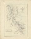
| Date: | 1861 |
|---|---|
| Description: | This map shows Manassas during the First Battle of Bull Run, in which the 2nd Wisconsin Infantry fought, and the Leesburg area, the site of the Battle of B... |

| Date: | 1862 |
|---|---|
| Description: | This map illustrates the official plan for the siege of Yorktown, Virginia, and indicates the headquarters of Generals McClellan, Porter, Woodbury, and Hei... |

| Date: | 1862 |
|---|---|
| Description: | This map shows the region of southeastern Virginia which served as the setting for the Peninsular Campaign of 1862. A few battle sites are marked by crosse... |

| Date: | 1862 |
|---|---|
| Description: | This map of the Mississippi River between Island No. 8, northeast of New Madrid, Missouri, and Tiptonville, Tennessee, depicts the Confederate defenses at ... |

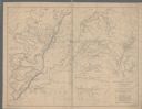
| Date: | 1863 |
|---|---|
| Description: | These detailed topographical maps of the Battle of Gettysburg show drainage, vegetation, roads, railroads, fences, houses with names of residents, and a de... |

| Date: | 1863 |
|---|---|
| Description: | These detailed topographical maps of the Battle of Gettysburg show drainage, vegetation, roads, railroads, fences, houses with names of residents, and a de... |

| Date: | 1863 |
|---|---|
| Description: | This colored map of the Battle of Chattanooga depicts the positions of the Union and Confederate troops before the battle and on each day of the battle. Al... |

| Date: | 1863 |
|---|---|
| Description: | This map shows drainage, vegetation, roads, railroads, fences, dwellings with names of inhabitants, and land owned by the United States. Union and Confeder... |
| Date: | 1863 |
|---|---|
| Description: | This map depicts the opening battles in the Union campaign against Vicksburg, Mississippi, in May 1863. Noted are the Battle of Port Gibson, May 1, 1863, t... |

| Date: | 1863 |
|---|---|
| Description: | A general map of the southeastern United States showing Missouri, Kentucky, West Virginia, Virginia, North Carolina, South Carolina, Georgia, Florida, Alab... |

| Date: | 1863 |
|---|---|
| Description: | This map of the Battle of Chattanooga depicts roads, railroads, drainage, vegetation, relief, and the names of residents in the outlying areas. Fourteen Wi... |

| Date: | 1864 |
|---|---|
| Description: | This map of the Atlanta area shows entrenchments, relief by hachures, vegetation, drainage, roads, railroads, towns, and the names of a few residents in th... |
| Date: | 1864 |
|---|---|
| Description: | This map of northwestern Georgia shows dates and troop positions between Chattanooga, Tennessee, and Jonesboro, Georgia, May-September, 1864. Wisconsin uni... |
If you didn't find the material you searched for, our Library Reference Staff can help.
Call our reference desk at 608-264-6535 or email us at: