 Filter: Categories of Wisconsin Historical Images
Filter: FORMAT_TYPE of prints, photomechanical
Filter: Subject of battles
Filter: Subject of water
Filter: Categories of Wisconsin Historical Images
Filter: FORMAT_TYPE of prints, photomechanical
Filter: Subject of battles
Filter: Subject of water
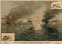
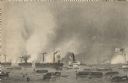
| Date: | 1885 |
|---|---|
| Description: | "Terrific Engagement between the 'Monitor' and 'Merrimac.'" Battle scene of the Civil War battle produced by the McCormick Harvesting Machine Company. Smal... |
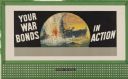
| Date: | 1944 |
|---|---|
| Description: | Treasury Design No. 36, "Periscope." The poster features a Japanese battle ship under attack as seen through a periscope. |
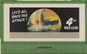
| Date: | 1944 |
|---|---|
| Description: | Treasury Design No. 33, "Periscope View - 4th War Loan." The poster features a Japanese battle ship under attack as seen through a periscope. |

| Date: | 1943 |
|---|---|
| Description: | Treasury Design No. 29, "Wedding." The poster features two contrasting scenes. On the left is a dark naval battle commencing on stormy waters. On the right... |

| Date: | 1943 |
|---|---|
| Description: | Treasury Design No. 26, "Invasion." The poster features ships landing on the coast and soldiers racing up the beach as explosions rain down around them. |
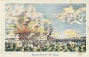
| Date: | 1861 |
|---|---|
| Description: | Color lithograph of the fort in the midst of the bombardment, published by Bingham & Dodd, Hartford, Connecticut. |

| Date: | 07 1861 |
|---|---|
| Description: | Etching of a battle scene during the retreat from Manassas. Originally published by Virtue & Company Publishers of New York. |
| Date: | |
|---|---|
| Description: | Etching of the "Attack upon Roanoke Island" by troops landing from naval vessels, after a painting by Chappel. |

| Date: | 1864 |
|---|---|
| Description: | (U.S. 39th Cong. 1stt Sess. Report of Chief engineer) The legend in the upper left corner contains a brief resume of each day's action while the map sho... |

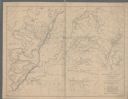
| Date: | 1850 |
|---|---|
| Description: | A hand-colored map showing portions of present-day Iron and Vilas counties north of the Manitowish River as part of the Upper Peninsula of Michigan. The Wi... |

| Date: | 1862 |
|---|---|
| Description: | This map of the Mississippi River between Island No. 8, northeast of New Madrid, Missouri, and Tiptonville, Tennessee, depicts the Confederate defenses at ... |

| Date: | 1863 |
|---|---|
| Description: | These detailed topographical maps of the Battle of Gettysburg show drainage, vegetation, roads, railroads, fences, houses with names of residents, and a de... |
| Date: | 1863 |
|---|---|
| Description: | This map depicts the opening battles in the Union campaign against Vicksburg, Mississippi, in May 1863. Noted are the Battle of Port Gibson, May 1, 1863, t... |

| Date: | 1863 |
|---|---|
| Description: | A general map of the southeastern United States showing Missouri, Kentucky, West Virginia, Virginia, North Carolina, South Carolina, Georgia, Florida, Alab... |

| Date: | 1864 |
|---|---|
| Description: | This map of the battlefield on the North Anna River at Hanover Junction illustrates the Union positions in blue and Confederate positions in red. Roads, ra... |

| Date: | 1864 |
|---|---|
| Description: | This colored map of the southern and eastern states shows locations of battles and skirmishes from 1861 through May 1864 with red dots or red underlining o... |

| Date: | 1864 |
|---|---|
| Description: | This map depicts the positions of Union forces, in blue, and Confederate forces, in red, at the end of 1863 after the cessation of the Knoxville Campaign. ... |

| Date: | 1864 |
|---|---|
| Description: | This map of the area of the First Battle of Bull Run shows military positions and troop movements as well as the names of landowners, vegetation and land u... |

| Date: | 1865 |
|---|---|
| Description: | This map of the Bentonville, N.C., battlefield illustrates the positions of the Union and the Confederate troops, roads, rivers, vegetation, and the names ... |

| Date: | 1918 |
|---|---|
| Description: | United States government bonds poster in the Fourth Liberty Loan "B" series. "Buy Liberty Bonds. Fourth Liberty Loan." Depicts enemy aircraft bombing New Y... |
If you didn't find the material you searched for, our Library Reference Staff can help.
Call our reference desk at 608-264-6535 or email us at: