 Filter: Categories of Wisconsin Historical Images
Filter: FORMAT_TYPE of prints, photomechanical
Filter: Subject of bays
Filter: Creator Name of Unknown
Filter: Categories of Wisconsin Historical Images
Filter: FORMAT_TYPE of prints, photomechanical
Filter: Subject of bays
Filter: Creator Name of Unknown

| Date: | 1920 |
|---|---|
| Description: | Caption reads: "Mammoth Ore Docks, Ashland, Wis." A building and roads are in the foreground. Several ore ships can be seen. |

| Date: | 1905 |
|---|---|
| Description: | View across field and fence downhill towards the town of Fish Creek and the bay. Caption reads: "Greetings from Fish Creek, Wis." |

| Date: | 1905 |
|---|---|
| Description: | Indian cemetery. A large body of water is in the background. Caption reads: "Indian Burying Grounds, Bayfield, Wis." |

| Date: | |
|---|---|
| Description: | The Old Mission Inn, originally built as a mission house in 1832 by the Congregational mission established by Frederick Ayer in 1830. In later years furthe... |

| Date: | 1879 |
|---|---|
| Description: | Map of Oconto and Marinette counties. |

| Date: | 1909 |
|---|---|
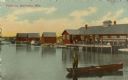
| Description: | View of a boating scene off of the shore of Marinette and Menominee. Two boys are walking on the pier on the left, and a crowd of people are gathered at th... |
| Date: | 1912 |
|---|---|
| Description: | View across water toward buildings on the right, with men standing on a platform at the shoreline in front of a large building. Three more smaller building... |
| Date: | 1910 |
|---|---|
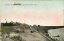
| Description: | Walkway on the bluff leading down to a pavilion on the shoreline. Houses are in the background. Caption reads: "Pavilion at Bendersville, near Green Bay, W... |

| Date: | 1954 |
|---|---|
| Description: | View looking west from Eagle Bluff toward Nicolet Bay, the Strawberry Islands, and Chambers Island. Three people are sitting on the stone wall of the overl... |

| Date: | 1863 |
|---|---|
| Description: | Map of the west end of Lake Superior, including Superior, St. Louis, and Allouez Bays. |

| Date: | 1860 |
|---|---|
| Description: | This map, traced from John Farmer's 1860 Map of the states of Michigan and Wisconsin, shows the boundary between Michigan's Upper Peninsula and northern Wi... |

| Date: | 1886 |
|---|---|
| Description: | This map, originally published in the 1881 Illustrated historical atlas of Wisconsin, shows the township and range system, sections,towns, cities and villa... |

| Date: | 1914 |
|---|---|
| Description: | Includes index of University of Wisconsin buildings, churches, and public buildings. Top of Map reads: '"GET A SQUARE DEAL" AT THE COLLEGE BOOK STORE SHOWN... |

| Date: | 1890 |
|---|---|
| Description: | This map of Superior shows city wards, bays, docks, some businesses and points of interest. Relief is shown by hachures. The back of the map features a typ... |

| Date: | 1898 |
|---|---|
| Description: | This map of Superior shows city wards, bays, docks, and some businesses and points of interest. Relief is shown by hachures. The map probably came from a C... |

| Date: | 1860 |
|---|---|
| Description: | This map of Superior is oriented with north to the upper left. Relief is shown by hachures and water depths are shown by soundings. Lake Superior and bays ... |

| Date: | 1930 |
|---|---|
| Description: | This map shows a plat of the town, local streets, railroads, creeks, part of Fox River, and part of the bay of Green Bay. The location of the original fort... |

| Date: | 1924 |
|---|---|
| Description: | This map is pen, pencil, and watercolor on paper and shows land ownership by name, local streets, railroads, and part of Chequamegon Bay. The map includes ... |

| Date: | 1914 |
|---|---|
| Description: | This map has relief shown by hachures and shows local streets, wards, districts, railroads, Fox River, and part of Bay of Green Bay. Wards are shown in dar... |

| Date: | 1891 |
|---|---|
| Description: | This colorful map shows additions, railroads, docks, streets, established dock lines, marshes, and proposed belt line railroad. The map covers west and sou... |
If you didn't find the material you searched for, our Library Reference Staff can help.
Call our reference desk at 608-264-6535 or email us at: