 Filter: Categories of Wisconsin Historical Images
Filter: FORMAT_TYPE of prints, photomechanical
Filter: Subject of education
Filter: Subject of bridges
Filter: Categories of Wisconsin Historical Images
Filter: FORMAT_TYPE of prints, photomechanical
Filter: Subject of education
Filter: Subject of bridges

| Date: | 1867 |
|---|---|
| Description: | Bird's-eye map of La Crosse with nine insets of residences, schools, and the Court House and Jail. |

| Date: | 1875 |
|---|---|
| Description: | Bird's-eye map of Black River Falls, looking southwest. |

| Date: | 1872 |
|---|---|
| Description: | Birds-eye drawing of Eau Claire depicts street names and street locations, houses, trees, bridges, piers, canals, railroads, and the Chippewa and Eau Clair... |

| Date: | 1874 |
|---|---|
| Description: | Bird's-eye view of Waukesha, looking southwest, with insets of State Industrial School, Court House, and Fountain Spring House. |

| Date: | 1879 |
|---|---|
| Description: | This map is a bird's-eye view of Wausau, the County Seat of Marathon County. The map features an index of points of interest. |
| Date: | 1915 |
|---|---|
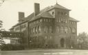
| Description: | The Central School, later a part of Stout State College. Caption reads: "Central School, Menomonie, Wis." |

| Date: | 1897 |
|---|---|
| Description: | This 1897 map of Sawyer County, Wisconsin, shows the township and range system, sections, roads, farm houses, camps, school houses, dams, bridges, Indian r... |

| Date: | 1902 |
|---|---|
| Description: | This 1902 map of the eastern portion of Sawyer County, Wisconsin, shows the township and range system, sections, roads, farm houses, camps, school houses, ... |

| Date: | 1831 |
|---|---|
| Description: | Map of the city of Louisville, Kentucky on the Ohio River showing streets and numbered lots. The Ohio River, Corn Island, and the Louisville and Portland C... |

| Date: | 1874 |
|---|---|
| Description: | Bird's-eye view map of Appleton, Wisconsin. Map reads: "NOTE.-Since the above cut was engraved, the Fox River Pulp & Paper Co.'s Mammoth Mills have been er... |
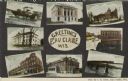
| Date: | 1910 |
|---|---|
| Description: | Color enhanced postcard with eight views of buildings, bridges, and dams. In the center is written: "Greetings from Eau Claire Wis." |
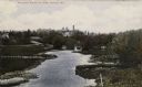
| Date: | |
|---|---|
| Description: | Elevated view of a river with grassy and tree-lined banks. The Wisconsin School for the Deaf is on a hill in the far distance beyond a bridge over the rive... |

| Date: | 1967 |
|---|---|
| Description: | Aerial view of the State University adjacent to the Chippewa River. Caption reads: "State University - Eau Claire, Eau Claire, Wis." |

| Date: | 1874 |
|---|---|
| Description: | Birds-eye view of Appleton Wisconsin. In the foreground are people fishing, strolling, and looking over the canal towards the Fox River. Streets and buildi... |

| Date: | 1908 |
|---|---|
| Description: | The high school building. A pedestrian bridge is on the left side of the building. Caption reads: "Central School, Menomonie, Wis." |

| Date: | |
|---|---|
| Description: | Central High School and Stout Manual Training School connected by pedestrian bridge. Two men are walking on the lawn towards the buildings. Caption reads: ... |

| Date: | 04 01 1905 |
|---|---|
| Description: | Text on front reads: "Sheboygan, Wis. the .......190." The person writing the postcard added the date and year. Four scenes are displayed within Art Nouvea... |
If you didn't find the material you searched for, our Library Reference Staff can help.
Call our reference desk at 608-264-6535 or email us at:

