 Filter: Categories of Wisconsin Historical Images
Filter: FORMAT_TYPE of prints, photomechanical
Filter: Subject of fortification
Filter: Subject of dwellings
Filter: Categories of Wisconsin Historical Images
Filter: FORMAT_TYPE of prints, photomechanical
Filter: Subject of fortification
Filter: Subject of dwellings

| Date: | 1835 |
|---|---|
| Description: | Little Lake Butte Des Morts just north of Lake Winnebago where Governor Lewis Cass of Michigan, and Thomas McKenney, head of the Bureau of Indian Affairs (... |
| Date: | 1823 |
|---|---|
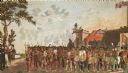
| Description: | British evacuation of their fort at Prairie du Chien after the end of the War of 1812. Fort Shelby, the first fort at Prairie du Chien, was built in 1814 b... |
| Date: | |
|---|---|
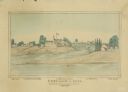
| Description: | View of Chicago from Chicago River. The homes of John Dean, J. Baptiste Beaubien, Dr. Walcott, and John Kinzie are identified by number. Fort Dearborn can ... |
| Date: | 1930 |
|---|---|
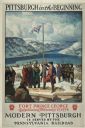
| Description: | An original lithograph promoting Pittsburgh, Pennsylvania, and the Pennsylvania Railroad through artist N.C. Wyeth's depiction of the establishment of Fort... |
| Date: | 1930 |
|---|---|
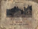
| Description: | Holiday card printed on a sheet of copper. It has a scene of log buildings, a stockade fence, and woods in the background. Above is the text "Michigan Copp... |

| Date: | 1864 |
|---|---|
| Description: | This map created during the Civil War indicates Confederate fortifications, houses, names of residents, towns, roads, railroads, relief by hachures, draina... |

| Date: | 1867 |
|---|---|
| Description: | This 1867 manuscript map by Increase Lapham shows the topography and geology of the Blue Mounds region in the Town of Brigham in Iowa County and the towns ... |

| Date: | 1911 |
|---|---|
| Description: | This hand-colored map is a 1911 copy of a map drawn by Gaspard-Joseph Chaussegros de Léry in 1730 showing the Fox River from its mouth at Green Bay to Lake... |

| Date: | |
|---|---|
| Description: | A granite stone behind a low fence commemorating the Black Hawk War. Text on front of card reads: "Black Hawk War Monument Erected by Fort Atkinson D.A.R.,... |

| Date: | 1615 |
|---|---|
| Description: | Illustration of the Huron Indians and French explorers attacking an Iroquois fort near present day Fenner, New York. A wooden platform was constructed to f... |
If you didn't find the material you searched for, our Library Reference Staff can help.
Call our reference desk at 608-264-6535 or email us at: