 Filter: Categories of Wisconsin Historical Images
Filter: FORMAT_TYPE of prints, photomechanical
Filter: Subject of fur trade
Filter: Categories of Wisconsin Historical Images
Filter: FORMAT_TYPE of prints, photomechanical
Filter: Subject of fur trade
| Date: | |
|---|---|
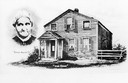
| Description: | Inset of head and shoulders portrait of "Queen Marinette" along with a depiction of her home, which was one of the earliest houses in Marinette. She was th... |
| Date: | 02 1892 |
|---|---|
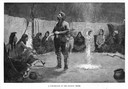
| Description: | Engraving of a fur trader standing in the middle of a circle of seated Indians in their council tepee. |
| Date: | 1833 |
|---|---|
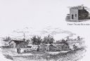
| Description: | Illustration of the Solomon Juneau fur trading post at Milwaukee in 1833. |
| Date: | 1925 |
|---|---|
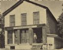
| Description: | Former building of the Astor Company, also known as the Brisbois Fur Trading Post. The American Fur Company, which had been organized by John Jacob Astor i... |

| Date: | 1761 |
|---|---|
| Description: | A plan of the Straits of St. Mary and Michilimakinac, to shew the situation and importance of the two westernmost settlements of Canada for the fur trade. ... |
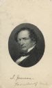
| Date: | |
|---|---|
| Description: | Carte-de-visite portrait engraving of Solomon Laurent Juneau (1793-1856), Wisconsin fur trader and politician. |
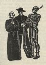
| Date: | 1941 |
|---|---|
| Description: | Woodcut illustration of three standing figures, possibly a missionary, a fur trader, and an American Indian, depicting Wisconsin history. |

| Date: | 1956 |
|---|---|
| Description: | This map shows Lake Wisconsin, roads, highways, parks, resort areas, camps, gardens, and Wisconsin State experimental game and fur farm. The back of the ma... |

| Date: | 1845 |
|---|---|
| Description: | This map shows lakes, rivers, Chippewa land, the U.S. Mineral Land Agency, boundary between U.S. and Canada, Methodist and Catholic missions, and American ... |

| Date: | 1949 |
|---|---|
| Description: | This pictorial map shows the United States west of the Mississippi, including Indian Tribes, historic trails, forts, trading posts, mountain ranges, lakes ... |

| Date: | 1974 |
|---|---|
| Description: | Map of Wisconsin with drawings illustrating historic places and events throughout the state. The Great Seal of the State of Wisconsin appears at the top ri... |
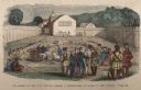
| Date: | 1859 |
|---|---|
| Description: | Hand-colored engraving showing fur company agents making a distribution of goods to Indians, some of whom are seated on the ground, in a fenced courtyard w... |
If you didn't find the material you searched for, our Library Reference Staff can help.
Call our reference desk at 608-264-6535 or email us at: