 Filter: Categories of Wisconsin Historical Images
Filter: FORMAT_TYPE of prints, photomechanical
Filter: Subject of intellectual life
Filter: Subject of express highways
Filter: Categories of Wisconsin Historical Images
Filter: FORMAT_TYPE of prints, photomechanical
Filter: Subject of intellectual life
Filter: Subject of express highways
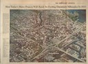
| Date: | 03 09 1965 |
|---|---|
| Description: | Aerial view and illustration of projected projects, including interstates and interchanges in downtown Milwaukee, for the 1970's. |
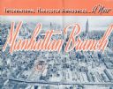
| Date: | 1937 |
|---|---|
| Description: | Cover of a brochure celebrating a new International Harvester Manhattan branch, featuring an aerial photograph of Manhattan, including the corner of West 4... |
| Date: | 1955 |
|---|---|
| Description: | This set of 32 maps and an index show the (then) proposed route of the Wisconsin Turnpike. The index shows the entire route of the turnpike, and the major ... |

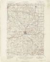
| Date: | 1929 |
|---|---|
| Description: | This map shows the entire state of Wisconsin and Minnesota and portions of Illinois and Iowa. Counties, cities, highways, lakes, and rivers are labeled. Ro... |
If you didn't find the material you searched for, our Library Reference Staff can help.
Call our reference desk at 608-264-6535 or email us at: