 Filter: Categories of Wisconsin Historical Images
Filter: FORMAT_TYPE of prints, photomechanical
Filter: Subject of intellectual life
Filter: Subject of factories
Filter: Categories of Wisconsin Historical Images
Filter: FORMAT_TYPE of prints, photomechanical
Filter: Subject of intellectual life
Filter: Subject of factories

| Date: | 1884 |
|---|---|
| Description: | A sign for Fauerbach's Brewery depicting a young woman and the brewery. |

| Date: | 1853 |
|---|---|
| Description: | Bird's-eye map of Milwaukee looking east toward Lake Michigan from a bluff, long since graded into a slope, at about 6th Street between Wisconsin Avenue an... |

| Date: | 1867 |
|---|---|
| Description: | Birds-eye drawing of Appleton, Outagamie Co., depicting street names and street layout, houses, the Fox River, the court house, jail, school houses, Lawren... |

| Date: | 1867 |
|---|---|
| Description: | Birds eye drawing of Fond du Lac depicts street names and street layouts, houses, buildings, trees, and the Fond du Lac River. A reference key at the botto... |
| Date: | 1883 |
|---|---|
| Description: | Lithographed advertising card for the Oliver Chilled Plow Works commemorating the new year, 1884. The card features two color illustrations within a gold f... |

| Date: | 1882 |
|---|---|
| Description: | Bird's-eye views of various sections of Milwaukee. |

| Date: | 1885 |
|---|---|
| Description: | Bird's-eye view of Sheboygan, with inset of J.J. Volrath Manufacturing Company. |

| Date: | 1913 |
|---|---|
| Description: | Bird's-eye map of Superior. "The New Steel Center." |

| Date: | 1885 |
|---|---|
| Description: | Bird's-eye map of Waupun on the Rock River. There is an inset at top center of "Althouse, Wheeler & Co., Windmills and Pumps." |

| Date: | 1872 |
|---|---|
| Description: | Birds-eye drawing of Eau Claire depicts street names and street locations, houses, trees, bridges, piers, canals, railroads, and the Chippewa and Eau Clair... |

| Date: | 1896 |
|---|---|
| Description: | Bird's-eye view of Washburn, with twenty vignettes around side, water in foreground with docks and lumber corral. Thirty-three locations identified in key ... |

| Date: | 1910 |
|---|---|
| Description: | Bird's-eye view looking east, with Washburn Harbor at center and Chequamegon Bay in Lake Superior covering most of the upper image. Streets with buildings... |

| Date: | 1874 |
|---|---|
| Description: | Bird's-eye view of Waukesha, looking southwest, with insets of State Industrial School, Court House, and Fountain Spring House. |

| Date: | 1879 |
|---|---|
| Description: | This map is a bird's-eye view of Wausau, the County Seat of Marathon County. The map features an index of points of interest. |

| Date: | 1937 |
|---|---|
| Description: | Bird's-eye view of Milwaukee in 1853 details building features and city layout from southwest. Important buildings are numbered in a silhouette drawing bel... |

| Date: | 1915 |
|---|---|
| Description: | Advertisement reads: "Castle-Pierce Printing Company" and "Feb. 1915". Text on right reads: "The Heart of Oshkosh. This birds-eye view represents about one... |
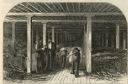
| Date: | 1877 |
|---|---|
| Description: | Etching of interior of bonded warehouse with four men present, two conversing and two rolling barrels. |
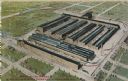
| Date: | 1910 |
|---|---|
| Description: | Aerial view of the factory surrounded by fields, roads, and several houses, as well as the railroad tracks that go around the building. Caption reads: "Wes... |
If you didn't find the material you searched for, our Library Reference Staff can help.
Call our reference desk at 608-264-6535 or email us at:

